No higher resolution available.
Tichitt_Tradition_drystone_tumulus.jpg (388 × 214 pixels, file size: 112 KB, MIME type: image/jpeg)
Summary
| Description |
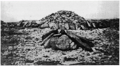
English: Tichitt Tradition drystone tumulus photographed by Dr. M. Ould-Khattar (1995: 457, Fig. 71) during his fieldwork in the Dhar Tagant region during the late 1980's, approximately 100–150 km from our study area. Visual inspection using satellite imagery suggests that the structures within the Tabarit East tumulus field may resemble this example. Dhar Tagant. |
| Date | |
| Source | https://www.sciencedirect.com/science/article/pii/S030544032300095X |
| Author | Jonathan S. Lim and Gonzalo J. Linares Matás |
Licensing
This file is licensed under the Creative Commons Attribution 4.0 International license.
- You are free:
- to share – to copy, distribute and transmit the work
- to remix – to adapt the work
- Under the following conditions:
- attribution – You must give appropriate credit, provide a link to the license, and indicate if changes were made. You may do so in any reasonable manner, but not in any way that suggests the licensor endorses you or your use.
File history
Click on a date/time to view the file as it appeared at that time.
| Date/Time | Thumbnail | Dimensions | User | Comment | |
|---|---|---|---|---|---|
| current | 12:05, 5 August 2023 | | 388 × 214 (112 KB) | Daniel Power of God | Uploaded a work by Jonathan S. Lim and Gonzalo J. Linares Matás from https://www.sciencedirect.com/science/article/pii/S030544032300095X with UploadWizard |
File usage
The following pages on the English Wikipedia use this file (pages on other projects are not listed):