Size of this preview: 600 × 600 pixels. Other resolutions: 240 × 240 pixels | 480 × 480 pixels | 768 × 768 pixels | 1,024 × 1,024 pixels | 2,048 × 2,048 pixels | 2,560 × 2,560 pixels.
Original file (2,560 × 2,560 pixels, file size: 150 KB, MIME type: image/gif, looped)
Summary
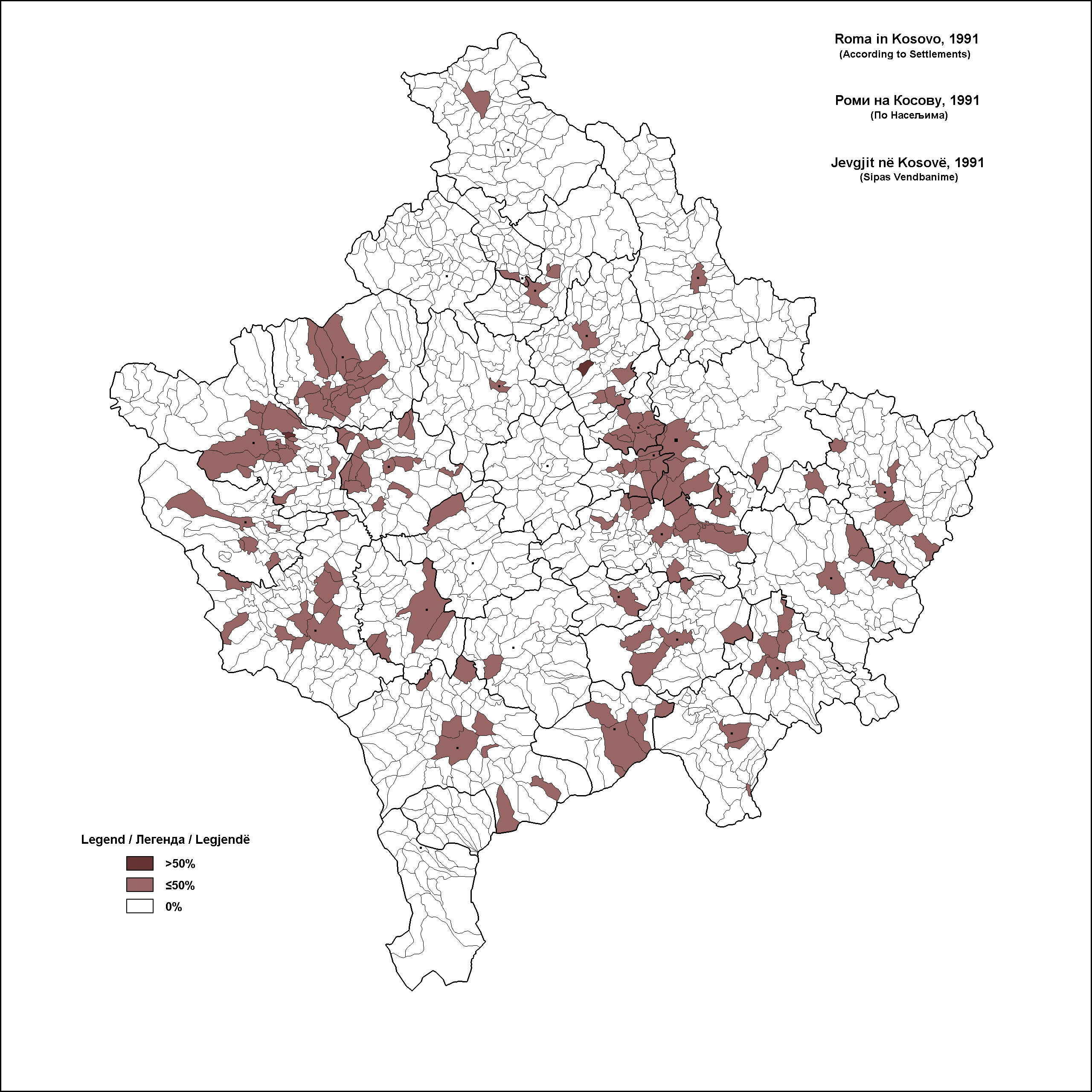
This map shows Roma in Kosovo. The poligons show where they were, according to the 1991 census. Due to the boycott of the census by the Albanians (the majority in 1991), it is difficult to determine if the Roma were a majority anywhere. One poligon labels them as the majority, in the Pec municipality. They were the majority there in 1981, so I figure that they were in 1991 too. The other one in the municipality of vucitrn can be seen on this map, though there are some mistakes on it, so it's questionable... http://www.kosovo.net/serb-roma91.jpg
| Description |
Српски / srpski: Етничка карта удела Рома на Косова и Метохије 1991. године. |
| Date | 26 July 2009 (original upload date) |
| Source | Transferred from sr.wikipedia to Commons by Micki using CommonsHelper. |
| Author | The original uploader was Lilic at Serbian Wikipedia. |
Licensing
This file is licensed under the Creative Commons Attribution-Share Alike 3.0 Serbia license.
- You are free:
- to share – to copy, distribute and transmit the work
- to remix – to adapt the work
- Under the following conditions:
- attribution – You must give appropriate credit, provide a link to the license, and indicate if changes were made. You may do so in any reasonable manner, but not in any way that suggests the licensor endorses you or your use.
- share alike – If you remix, transform, or build upon the material, you must distribute your contributions under the same or compatible license as the original.


|
Permission is granted to copy, distribute and/or modify this document under the terms of the GNU Free Documentation License, Version 1.2 or any later version published by the Free Software Foundation; with no Invariant Sections, no Front-Cover Texts, and no Back-Cover Texts. A copy of the license is included in the section entitled GNU Free Documentation License. |
Original upload log
The original description page was here. All following user names refer to sr.wikipedia.
- 2010-12-31 18:41 Lilic 2756×3104× (223404 bytes)
- 2009-07-26 23:13 Lilic 3118×3362× (229471 bytes) == Опис == Етничка карта удела Хрвата на Косова и Метохије 1961. године.
File history
Click on a date/time to view the file as it appeared at that time.
| Date/Time | Thumbnail | Dimensions | User | Comment | |
|---|---|---|---|---|---|
| current | 09:55, 10 November 2023 | | 2,560 × 2,560 (150 KB) | Beao | Removed watermark |
| 17:24, 17 April 2011 |  | 2,560 × 2,560 (151 KB) | Lilic | some changes | |
| 18:52, 22 March 2011 |  | 2,756 × 3,104 (218 KB) | File Upload Bot (Magnus Manske) | {{BotMoveToCommons|sr.wikipedia|year={{subst:CURRENTYEAR}}|month={{subst:CURRENTMONTHNAME}}|day={{subst:CURRENTDAY}}}} {{Information |Description={{sr|Етничка карта удела Рона на Косова и Метохије 1991. године. |
File usage
The following pages on the English Wikipedia use this file (pages on other projects are not listed):
Global file usage
The following other wikis use this file:
- Usage on mk.wikipedia.org
- Usage on sq.wikipedia.org
- Usage on sr.wikipedia.org