Old_Mobile_Map_1702.jpg (664 × 514 pixels, file size: 59 KB, MIME type: image/jpeg)
Summary
| Description |
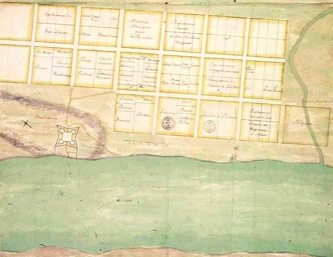
Français : Plan de la ville et du fort de La Mobile, 1702, Dépôt des fortifications des colonies, Louisiane, III 6 PFB 119. English: Plan for the settlement of La Mobile (near Twenty-Seven Mile Bluff in Mobile County, Alabama). The drawing was presumably prepared by Charles Levasseur in 1702. The map is now housed in the Archives nationales d'outre-mer in Aix-en-Provence |
| Date | 18th century |
| Source | Archives nationales d'outre-mer |
| Author | Leeannedy at en.wikipedia |
Licensing
|
This work is in the public domain in its country of origin and other countries and areas where the copyright term is the author's life plus 70 years or fewer.
| |
| This file has been identified as being free of known restrictions under copyright law, including all related and neighboring rights. | |
Original upload log
Upload date | User | Bytes | Dimensions | Comment
- 2007-05-15 22:10 (UTC) | Leeannedy | 29789 (bytes) | 675×518 | Plan for the settlement of La Mobile (near Twenty-Seven Mile Bluff in Mobile County, Alabama). The drawing was presumably prepared by Charles Levasseur in 1702. The map is now housed in the archives of the Centre des Archives d'Outre-mer in France.
File history
Click on a date/time to view the file as it appeared at that time.
| Date/Time | Thumbnail | Dimensions | User | Comment | |
|---|---|---|---|---|---|
| current | 19:34, 2 June 2013 | | 664 × 514 (59 KB) | Jeangagnon | correction automatique |
| 10:29, 21 September 2011 |  | 675 × 518 (29 KB) | SreeBot | (Original text) : Plan for the settlement of La Mobile (near Twenty-Seven Mile Bluff in Mobile County, Alabama). The drawing was presumably prepared by Charles Levasseur in 1702. The map is now housed in the archives of the Centre des Archives d'Outre-m |
File usage
Global file usage
The following other wikis use this file: