No higher resolution available.
Germany_and_Poland_borders_during_the_20th_century.gif (500 × 320 pixels, file size: 6 KB, MIME type: image/gif)
Summary
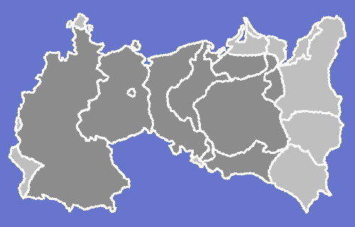
Anachronical map of Germany and Poland border changes during the 20th century.
The borders represent:
Until World War I:
After World War I until Anschluss:
After World War II until the Revolutions of 1989:
After the end of the Soviet Union:
I made this map on a Beige G3 running Photoshop using these maps as reference:
Licensing:
Other versions
A flag-coloured one… is here, at Wikimedia Commons.
_and_their_different_borders_during_the_20th_century.gif)
File history
Click on a date/time to view the file as it appeared at that time.
| Date/Time | Thumbnail | Dimensions | User | Comment | |
|---|---|---|---|---|---|
| current | 00:48, 15 August 2008 | | 500 × 320 (6 KB) | MaGioZal (talk | contribs) | Anachronical map pf Germany and Poland border changes during the 20th century. I made this map usaing these maps as reference: KingdomofPoland1815.jpg [[:Image:Österreich-Ungarns Ende.png|Österreich-Ungar |
You cannot overwrite this file.
File usage
The following pages on the English Wikipedia use this file (pages on other projects are not listed):
- Talk:West Germany/Archive 1
- Wikipedia talk:German-speaking Wikipedians' notice board/Archive 6
- Template:Germany and Poland Border Changes 20th century
- Template talk:Territorial evolution of Germany
- Template talk:Territorial evolution of Poland
- Portal talk:Poland/Poland-related Wikipedia notice board/Archive 11