
Size of this preview: 800 × 376 pixels. Other resolutions: 320 × 150 pixels | 640 × 301 pixels | 1,024 × 481 pixels | 1,880 × 884 pixels.
Original file (1,880 × 884 pixels, file size: 407 KB, MIME type: image/jpeg)
Summary
| Description |
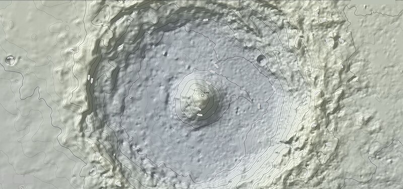
English: A topographic map created using Mars Orbiter Laser Altimeter (MOLA) data. This map show the relative elevation in 100 meter elevation contour lines (dashed) and 500 meter elevation contour lines (bold) with a total elevation uncertainty of +/- 6 meters. |
| Date | |
| Source | Own work |
| Author | Mtraynier |
Licensing
I, the copyright holder of this work, hereby publish it under the following license:
This file is licensed under the Creative Commons Attribution-Share Alike 4.0 International license.
- You are free:
- to share – to copy, distribute and transmit the work
- to remix – to adapt the work
- Under the following conditions:
- attribution – You must give appropriate credit, provide a link to the license, and indicate if changes were made. You may do so in any reasonable manner, but not in any way that suggests the licensor endorses you or your use.
- share alike – If you remix, transform, or build upon the material, you must distribute your contributions under the same or compatible license as the original.
File history
Click on a date/time to view the file as it appeared at that time.
| Date/Time | Thumbnail | Dimensions | User | Comment | |
|---|---|---|---|---|---|
| current | 21:14, 24 September 2020 | | 1,880 × 884 (407 KB) | Jstuby | crop |
| 23:20, 26 June 2019 |  | 1,920 × 923 (308 KB) | Mtraynier | User created page with UploadWizard |
File usage
The following pages on the English Wikipedia use this file (pages on other projects are not listed):
Global file usage
The following other wikis use this file:
- Usage on bn.wikipedia.org
- Usage on es.wikipedia.org
- Usage on zh.wikipedia.org