![File:2018-06-07 02 Sycamore Gap Tree (Acer pseudoplatanus), next to Hadrian’s Wall UK.jpg](https://upload.wikimedia.org/wikipedia/commons/thumb/0/0e/2018-06-07_02_Sycamore_Gap_Tree_%28Acer_pseudoplatanus%29%2C_next_to_Hadrian%E2%80%99s_Wall_UK.jpg/800px-2018-06-07_02_Sycamore_Gap_Tree_%28Acer_pseudoplatanus%29%2C_next_to_Hadrian%E2%80%99s_Wall_UK.jpg)
Size of this preview: 800 × 394 pixels. Other resolutions: 320 × 158 pixels | 640 × 315 pixels | 1,024 × 504 pixels | 1,280 × 630 pixels | 2,560 × 1,260 pixels | 5,828 × 2,869 pixels.
Original file (5,828 × 2,869 pixels, file size: 10.78 MB, MIME type: image/jpeg)
Summary
Description2018-06-07 02 Sycamore Gap Tree (Acer pseudoplatanus), next to Hadrian’s Wall UK.jpg |
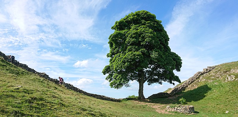
English: The Sycamore Gap Tree or “Robin Hood Tree” is a sycamore tree (Acer pseudoplatanus) standing next to Hadrian's Wall near Haltwhistle, Northumberland, England. Crag Lough and the villages of Once Brewed and Haltwhistle are nearby. Image taken on June 7, 2018. Follow-up Note: This 200-year-old tree was cut down in an act of vandalism on the night of September 27, 28, 2023. |
Date | |
Source | Own work |
Author | Gordon Leggett |
Other versions |
|
Attribution (required by the license) InfoField | Photo: Gordon Leggett / Wikimedia Commons / |
InfoField | Photo: Gordon Leggett / Wikimedia Commons |
Camera location | 55° 00′ 12″ N, 2° 22′ 26″ W ![]() | View this and other nearby images on: OpenStreetMap | ![]() |
---|
![]() |
NOTE: This image is a panorama of Sycamore Gap Tree consisting of 3 frames that were merged or stitched in Lightroom. As a result, this image necessarily underwent some form of digital manipulation. These manipulations may include blending, blurring, cloning, and colour and perspective adjustments. As a result of these adjustments, the image content may be slightly different from reality at the points where multiple images were combined. This manipulation is often required due to lens, perspective, and parallax distortions.
Boarisch | български | dansk | Deutsch | Zazaki | Ελληνικά | English | Canadian English | British English | Esperanto | español | eesti | suomi | français | hrvatski | magyar | italiano | 日本語 | 한국어 | македонски | മലയാളം | Nederlands | polski | português | русский | sicilianu | slovenščina | svenska | Türkçe | українська | العربية | 中文 | |
Licensing
I, the copyright holder of this work, hereby publish it under the following license:
![w:en:Creative Commons](https://upload.wikimedia.org/wikipedia/commons/thumb/7/79/CC_some_rights_reserved.svg/90px-CC_some_rights_reserved.svg.png)
![attribution](https://upload.wikimedia.org/wikipedia/commons/thumb/1/11/Cc-by_new_white.svg/24px-Cc-by_new_white.svg.png)
![share alike](https://upload.wikimedia.org/wikipedia/commons/thumb/d/df/Cc-sa_white.svg/24px-Cc-sa_white.svg.png)
This file is licensed under the Creative Commons Attribution-Share Alike 4.0 International license.
- You are free:
- to share – to copy, distribute and transmit the work
- to remix – to adapt the work
- Under the following conditions:
- attribution – You must give appropriate credit, provide a link to the license, and indicate if changes were made. You may do so in any reasonable manner, but not in any way that suggests the licensor endorses you or your use.
- share alike – If you remix, transform, or build upon the material, you must distribute your contributions under the same or compatible license as the original.
Captions
Sycamore Gap Tree (Acer pseudoplatanus), was next to Hadrian’s Wall, Haltwhistle, Northumberland UK
Items portrayed in this file
depicts
Acer pseudoplatanus
Sycamore Gap Tree
creator
some value
Wikimedia username: GRDN711
author name string: Gordon Leggett
copyright status
copyrighted
copyright license
Creative Commons Attribution-ShareAlike 4.0 International
source of file
original creation by uploader
inception
7 June 2018
coordinates of the point of view
55°0'11.999"N, 2°22'26.000"W
exposure time
0.00125 second
f-number
2
focal length
4.4 millimetre
ISO speed
40
instance of
photograph
media type
image/jpeg
checksum
c72f66039cbfed12cb0612ba8f769b470de1f0be
determination method: SHA-1
data size
11,306,655 byte
height
2,869 pixel
width
5,828 pixel
File history
Click on a date/time to view the file as it appeared at that time.
Date/Time | Thumbnail | Dimensions | User | Comment | |
---|---|---|---|---|---|
current | 13:05, 2 December 2021 | ![]() | 5,828 × 2,869 (10.78 MB) | GRDN711 | Uploaded own work with UploadWizard |
File usage
The following pages on the English Wikipedia use this file (pages on other projects are not listed):
Metadata
This file contains additional information, probably added from the digital camera or scanner used to create or digitize it.
If the file has been modified from its original state, some details may not fully reflect the modified file.
Image title |
|
---|---|
Camera manufacturer | SONY |
Camera model | G8142 |
Author | Gordon Leggett |
Exposure time | 1/800 sec (0.00125) |
F-number | f/2 |
ISO speed rating | 40 |
Date and time of data generation | 16:25, 7 June 2018 |
Lens focal length | 4.4 mm |
Latitude | 55° 0′ 12″ N |
Longitude | 2° 22′ 26″ W |
Altitude | 312.969 meters above sea level |
Short title |
|
Copyright holder |
|
City shown | Bardon Mill |
Horizontal resolution | 240 dpi |
Vertical resolution | 240 dpi |
Software used | Adobe Photoshop Lightroom Classic 11.0.1 (Windows) |
File change date and time | 05:01, 2 December 2021 |
Exif version | 2.31 |
Date and time of digitizing | 16:25, 7 June 2018 |
Shutter speed | 9.643856 |
APEX aperture | 2 |
Exposure bias | 0 |
Metering mode | Unknown |
Light source | Unknown |
Flash | Flash did not fire, compulsory flash suppression |
DateTimeOriginal subseconds | 0861661 |
DateTimeDigitized subseconds | 0861661 |
Color space | sRGB |
Custom image processing | Normal process |
Exposure mode | Auto exposure |
White balance | Auto white balance |
Digital zoom ratio | 1 |
Scene capture type | Standard |
Subject distance range | Unknown |
GPS time (atomic clock) | 15:25 |
Receiver status | Measurement in progress |
Geodetic survey data used | WGS-84 |
GPS date | 7 June 2018 |
GPS tag version | 0.0.2.2 |
Date metadata was last modified | 21:01, 1 December 2021 |
Unique ID of original document | 4E3BB07B650C2A1EB9C0F8DB25C27E77 |
Copyright status | Copyrighted |
Keywords |
|
Province or state shown | England |
Country shown | United Kingdom |
Sublocation of city shown | Sycamore Gap |
Code for country shown | GB |
IIM version | 4 |