
Size of this preview: 800 × 600 pixels. Other resolutions: 320 × 240 pixels | 640 × 480 pixels | 1,024 × 768 pixels | 1,280 × 960 pixels | 2,560 × 1,920 pixels | 4,000 × 3,000 pixels.
Original file (4,000 × 3,000 pixels, file size: 7.15 MB, MIME type: image/jpeg)
Summary
|
This is an image of a place or building that is listed on the National Register of Historic Places in the United States of America. Its reference number is 80004534. |
| Description |
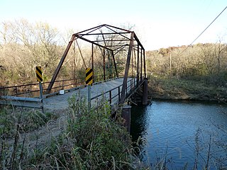
English: Frank's Ford Bridge, County Road 121 over the South Branch of the Zumbro River near Oronoco, Minnesota, USA. |
| Date | |
| Source | Own work |
| Author | Bobak Ha'Eri |
| Permission (Reusing this file) |
CC-By-SA-3.0 |
| Object location | | View this and other nearby images on: OpenStreetMap |
|---|
Photo taken by Bobak Ha'Eri, on October 10, 2010. Please observe license and properly cite in use outside Wikipedia. If you have any questions about the licensing, please feel free to use the contact information at my user page.
Licensing
I, the copyright holder of this work, hereby publish it under the following license:
This file is licensed under the Creative Commons Attribution 3.0 Unported license.
- You are free:
- to share – to copy, distribute and transmit the work
- to remix – to adapt the work
- Under the following conditions:
- attribution – You must give appropriate credit, provide a link to the license, and indicate if changes were made. You may do so in any reasonable manner, but not in any way that suggests the licensor endorses you or your use.
File history
Click on a date/time to view the file as it appeared at that time.
| Date/Time | Thumbnail | Dimensions | User | Comment | |
|---|---|---|---|---|---|
| current | 02:57, 17 October 2010 | | 4,000 × 3,000 (7.15 MB) | Bobak | {{Information |Description = {{en|'''Frank's Ford Bridge''', County Road 121 over the South Branch of the Zumbro River near Oronoco, Minnesota, USA.}} |Source = {{own}} |Date = 2010-10-14 |Author = [[ |
File usage
The following pages on the English Wikipedia use this file (pages on other projects are not listed):
Global file usage
The following other wikis use this file:
- Usage on de.wikipedia.org