
Size of this preview: 800 × 546 pixels. Other resolutions: 320 × 218 pixels | 640 × 437 pixels | 1,067 × 728 pixels.
Original file (1,067 × 728 pixels, file size: 1.58 MB, MIME type: image/png)
| Description |
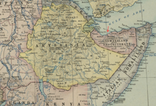
Detail of: Map of Africa and Adjoining Portions of Europe and Asia Author: National Geographic Society (U.S.) Publisher: National Geographic Society (U.S.) Date: 1922 Scale: 1:11,500,000 |
| Date | |
| Source | Boston Public Library, Map Center (Boston, Massachusetts, USA) / http://maps.bpl.org/id/m0612013 |
| Author | National Geographic Society (U.S.) |
This media file is in the public domain in the United States. This applies to U.S. works where the copyright has expired, often because its first publication occurred prior to January 1, 1929, and if not then due to lack of notice or renewal. See this page for further explanation.
|
 | |
 |
This image might not be in the public domain outside of the United States; this especially applies in the countries and areas that do not apply the rule of the shorter term for US works, such as Canada, Mainland China (not Hong Kong or Macao), Germany, Mexico, and Switzerland. The creator and year of publication are essential information and must be provided. See Wikipedia:Public domain and Wikipedia:Copyrights for more details.
|
File history
Click on a date/time to view the file as it appeared at that time.
| Date/Time | Thumbnail | Dimensions | User | Comment | |
|---|---|---|---|---|---|
| current | 15:54, 18 February 2013 | | 1,067 × 728 (1.58 MB) | M2545 | {{Information |Description=Detail of: Map of Africa and Adjoining Portions of Europe and Asia Author: National Geographic Society (U.S.) Publisher: National Geographic Society (U.S.) Date: 1922 Scale: 1:11,500,000 |Source=Boston Public Library, Ma... |
File usage
The following pages on the English Wikipedia use this file (pages on other projects are not listed):
Global file usage
The following other wikis use this file:
- Usage on fi.wikipedia.org
- Usage on ga.wikipedia.org
- Usage on ko.wikipedia.org
- Usage on simple.wikipedia.org