
Size of this preview: 626 × 599 pixels. Other resolutions: 251 × 240 pixels | 501 × 480 pixels | 802 × 768 pixels | 1,070 × 1,024 pixels | 2,139 × 2,048 pixels | 2,891 × 2,768 pixels.
Original file (2,891 × 2,768 pixels, file size: 1.67 MB, MIME type: image/jpeg)
Summary
| Description |
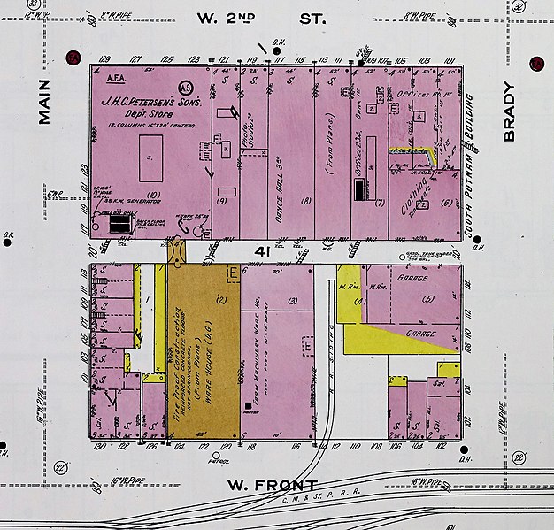
English: A 1910 Sanborn Fire Insurance Map cropped to show a commercial block in Downtown Davenport, Iowa, United States. In the upper left corner of the block is the former J.H.C. Petersen's Sons' Store. It is connected across the alley to the J.H.C. Petersen's Sons Wholesale Building (gold). The Schick's Express and Transfer Co. (pink) is immediately adjacent to the Petersen's Wholesale Building on the right. To the left of the Wholesale Building along Front Street (now River Drive) are the Schauder Hotel and the Clifton-Metropolitan Hotel on the corner. They eventually became part of the Petersen's store and were used for storage. Note the railroad siding on Front Street. Most of the buildings on this map are no longer extant. |
||
| Title | Sanborn Fire Insurance Map from Davenport, Scott County, Iowa. | ||
| Shelf ID | https://www.loc.gov/item/sanborn02624_004/ | ||
| Parent | https://www.loc.gov/resource/g4154dm.g02624191001/ | ||
| Sheet title | Image 21 of Sanborn Fire Insurance Map from Davenport, Scott County, Iowa. | ||
| Date | |||
| Source | File:Sanborn_Fire_Insurance_Map_from_Davenport,_Scott_County,_Iowa._LOC_sanborn02624_004-21.jpg | ||
| Author | Unknown author | ||
| Permission (Reusing this file) |
|
||
| Other versions |
|
||
| Location | Iowa · Davenport · Scott County | ||
| Part of | American Memory · Sanborn Maps · Geography And Maps Division |


| Camera location | | View this and other nearby images on: OpenStreetMap |
|---|
Licensing
|
This is a faithful photographic reproduction of a two-dimensional, public domain work of art. The work of art itself is in the public domain for the following reason:
The official position taken by the Wikimedia Foundation is that "faithful reproductions of two-dimensional public domain works of art are public domain".
This photographic reproduction is therefore also considered to be in the public domain in the United States. In other jurisdictions, re-use of this content may be restricted; see Reuse of PD-Art photographs for details. | ||||
File history
Click on a date/time to view the file as it appeared at that time.
| Date/Time | Thumbnail | Dimensions | User | Comment | |
|---|---|---|---|---|---|
| current | 15:53, 20 July 2020 | | 2,891 × 2,768 (1.67 MB) | Farragutful | Uploaded own work with UploadWizard |
File usage
The following pages on the English Wikipedia use this file (pages on other projects are not listed):