No edit summary Tags: Reverted Mobile edit Mobile web edit |
Tags: Reverted Mobile edit Mobile web edit |
||
| Line 48: | Line 48: | ||
File:Ковсакан - panoramio.jpg|A street in Zəngilan |
File:Ковсакан - panoramio.jpg|A street in Zəngilan |
||
File:Reservoire Khudapherin (Khoda Afarin), 2014.05.09 - panoramio.jpg|Khudapherin Reservoir in Zəngilan |
File:Reservoire Khudapherin (Khoda Afarin), 2014.05.09 - panoramio.jpg|Khudapherin Reservoir in Zəngilan |
||
File:Kovsakan112.jpg|A khachkar in Zəngilan |
|||
</gallery> |
</gallery> |
||
Revision as of 18:23, 20 October 2020
39°03′56″N 46°41′49″E / 39.06556°N 46.69694°E
Zangilan | |
|---|---|
| Zəngilan | |
 Zəngilan's nature | |
 Zangilan | |
| Coordinates: 39°03′56″N 46°41′49″E / 39.06556°N 46.69694°E | |
| Country | |
| Rayon | Zangilan |
| Population (2015) | |
| • Total | 500[1] |
| Time zone | UTC+4 (UTC) |
Zəngilan (, is a town and centre of the Zangilan Rayon of Azerbaijan.
History
The city was occupied by ethnic Armenian forces during the Nagorno-Karabakh War and was administered as part of Kashatagh Region by the de facto independent Republic of Artsakh.
Since the outbreak of the Syrian Civil War, a growing number of Armenian refugees from Syria had chosen to settle in this town, many of them farmers.[2][3][4]
Within the context of the 2020 Nagorno-Karabakh conflict, on the 20th of October 2020, Azerbaijani President Ilham Aliyev announced that Zangilan had been captured by Azerbaijani forces.[5] Azerbaijani Ministry of Defence released video from Zangilan shortly after the announcement and the location of the video was confirmed by third-party sources.[6][7][8]
Gallery
-
 Okhchuchay River in Zəngilan
 -
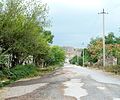 A street in Zəngilan
 -
 Khudapherin Reservoir in Zəngilan


References
- ^ http://stat-nkr.am/files/publications/2015/LXH_tverov_2015.pdf
- ^ "Armenia: Syrian Refugees Resettling in Occupied Azerbaijani Territory". EurasiaNet. 28 January 2013.
- ^ "Syrian-Armenians in NKR benefit from AGBU agricultural program".
- ^ "Armenia: refugees in the military". Deutsche Welle.
- ^ "President Ilham Aliyev: Zangilan city and 6 villages of the district, 18 villages of Fuzuli, Jabrayil, and Khojavand districts liberated". mod.gov.az. 20 October 2020.
- ^ @TvIctimai. "Zəngilan şəhərinə üçrəngli bayrağımız sancıldı!" (Tweet) – via Twitter. {{Cite tweet}}: Invalid |number= (help)
- ^ @Krummapper (October 20, 2020). "#Azerbaijan forces have been captured Zangilan. Coordinates: 39° 5.374'N 46° 39.641'E" (Tweet) – via Twitter. {{Cite tweet}}: |date= / |number= mismatch (help)
- ^ @GeromanAT (October 20, 2020). "Day 24 - Southern Sector" (Tweet) – via Twitter. {{Cite tweet}}: |date= / |number= mismatch (help)
- Zangilan at GEOnet Names Server
- World Gazetteer: Azerbaijan – World-Gazetteer.com
| Capital city | ||
|---|---|---|
| Provinces | ||
| Provincial capitals | ||
| Other urban communities |
| |
