Content deleted Content added
Supreme Deliciousness (talk | contribs) |
Supreme Deliciousness (talk | contribs) No edit summary |
||
| Line 1: | Line 1: | ||
'''Mountains in the [[Golan Heights]].''' |
'''Mountains in the [[Golan Heights]].''' |
||
==Mount Baron== |
|||
{{coord|33|09|30|N|35|46|43|E|type:mountain|display=inline}} |
|||
{| class="toccolours sortable" border="1" cellpadding="3" style="border-collapse:collapse" |
|||
({{lang-he|הר בראון}}, ''Har Baron'') is a part of an extinct [[volcano]] in the northeastern Golan Heights. The mountaintop is 1056 meters above sea level.<ref name=SouthernLebanonBorderArea/><ref name=SouthLebanonandVicinity/> |
|||
|- bgcolor=#CCCCFF |
|||
!Name |
|||
!Height |
|||
!Coordinates |
|||
!Notes |
|||
|- |
|||
|align="center" |Mount Baron ({{lang-he|הר בראון}}, ''Har Baron'') |
|||
| align="center" | 1056 m<ref name=SouthernLebanonBorderArea/><ref name=SouthLebanonandVicinity/> |
|||
| align="left" |{{coord|33|09|30|N|35|46|43|E|type:mountain|display=inline}} |
|||
| align="center" |Part of an extinct [[volcano]] in the northeastern Golan Heights. |
|||
|- |
|||
|align="center" |[[Mount Hermon]] ({{lang-ar|جبل الشيخ}}, ''Jabal el-Shaykh'', {{lang-he|הר חרמון}}, ''Har Hermon'') |
|||
| align="center" |1,804 m |
|||
| align="left" |{{coord|33|24|58|N|35|51|27|E|type:mountain|display=inline}} |
|||
| align="center" | Parts of Mount Hermons southern slopes fall within the northern Golan Heights. |
|||
|- |
|||
|align="center" |Mount Hosek ({{lang-he|הר חוזק}}, ''Har Hosek'') |
|||
| align="center" | 1158 m |
|||
| align="left" |{{coord|33|03|14|N|35|51|01|E|type:mountain|display=inline}} |
|||
| align="center" | Part of an extinct volcano in the eastern Golan Heights. |
|||
|- |
|||
|align="center" |Mount Ram ({{lang-he|הר רם}}, ''Har Ram'', lit. ''High Mountain'') |
|||
| align="center" | 1188 m<ref>Mount Ram - [http://books.google.com/books?id=-IFtAAAAMAAJ&q=%22mount+Ram%22&dq=%22mount+Ram%22&lr=&cd=18 ''Israel and Syria: peace and security on the Golan'']</ref> |
|||
| align="left" |{{coord|33|14|43|N|35|47|02|E|type:mountain|display=inline}} |
|||
| align="center" |Part of an extinct volcano in the northern Golan Heights. |
|||
|- |
|||
|align="center" |Mount Shifon ({{lang-he|הר שיפון}}, ''Har Shifon'') |
|||
| align="center" | 977 m<ref>Mount Shifon - [http://books.google.com/books?id=-IFtAAAAMAAJ&q=%22Mount+Shifon+(977m)%22&dq=%22Mount+Shifon+(977m)%22&cd=1 ''Israel and Syria: peace and security on the Golan''] p. 105.</ref> |
|||
| align="left" |{{coord|33|04|10|N|35|46|08|E|type:mountain|display=inline}} |
|||
| align="center" | Part of an extinct volcano in the northeastern the Golan Heights. |
|||
|- |
|||
|align="center" |Ras al-Ahmar/Mount Odem ({{lang-ar|رأس الأحمر}}, ''Ras al-Ahmar''; {{lang-he|הר אודם}}, ''Har Odem'', lit. ''ruby mountain'') |
|||
| align="center" | 1100 m |
|||
| align="left" |{{coord|33|11|55|N|35|45|15|E|type:mountain|display=inline}} |
|||
| align="center" | Part of an extinct volcano in the northern Golan Heights. |
|||
|- |
|||
|align="center" |Tall al-Faras/Mount Peres ({{lang-ar|تل الفرس}}, ''Tall al-Faras'', {{lang-he|הר פֶּרֶס}}, ''Har Peres'') |
|||
| align="center" | 929 m<ref name=SouthLebanonandVicinity/><ref name=CIA/> |
|||
| align="left" |{{coord|32|57|34|N|35|51|50|E|type:mountain|display=inline}} |
|||
| align="center" | Volcanic mountain located in central Golan Heights. |
|||
|- |
|||
|align="center" |Tall Abu an Nada/Mount Avital ({{lang-ar|تل أبو الندى, ''Tall Abu an Nada''}}, {{lang-he|הר אביטל}}) |
|||
| align="center" | 1204 m<ref name=SouthLebanonandVicinity/><ref name=CIA/> |
|||
| align="left" |{{Coord|33|06|38|N|35|47|45|E|type:mountain|display=inline}} |
|||
| align="center" | Part of an extinct volcano in the northeastern Golan Heights. |
|||
|- |
|||
|align="center" |Tal Al-Gharam/Mount Bental ({{lang-ar|تل الغرام, ''Tal Al-Gharam''}}, {{lang-he|הר בנטל}}, ''Har Bental'') |
|||
| align="center" | 1171 m |
|||
| align="left" |{{coord|33|07|45|N|35|47|09|E|type:mountain|display=inline}} |
|||
| align="center" |Part of an extinct volcano in the northeastern Golan Heights. |
|||
|- |
|||
|align="center" |Tall al Ghassaniyah/Mount Bnei Rasan ({{lang-ar|تلّ الغسانية}}, ''Tall al Ghassaniyah''; {{lang-he|הר בני רסן}}, ''Har Bnei Rasan'') |
|||
| align="center" | 1072 m<ref name=SouthernLebanonBorderArea /><ref name=SouthLebanonandVicinity /><ref name=CIA /> |
|||
| align="left" |{{coord|33|04|49|N|35|50|04|E|type:mountain|display=inline}} |
|||
| align="center" | Part of an extinct volcano in the eastern Golan Heights. Atop the mountain is the [[Golan Heights Wind Farm]]. |
|||
|- |
|||
|align="center" |Tall al Makhfi ({{lang-ar|تل المخفي}}, ''Tall al Makhfi'') |
|||
| align="center" | 1055 m<ref name=SouthernLebanonBorderArea /><ref name=SouthLebanonandVicinity /><ref name=CIA /> |
|||
| align="left" |{{coord|33|08|0|N|35|48|0|E|type:mountain|display=inline}} |
|||
| align="center" | Mountain in the northeastern Golan Heights, north of [[Quneitra]]. |
|||
|- |
|||
|align="center" |Tall Wardah/Mount Varda ({{lang-ar|تل وردة}}, ''Tall Wardah'', {{lang-he|הר ורדה}}, ''Har Varda'', lit. ''Rose mountain'') |
|||
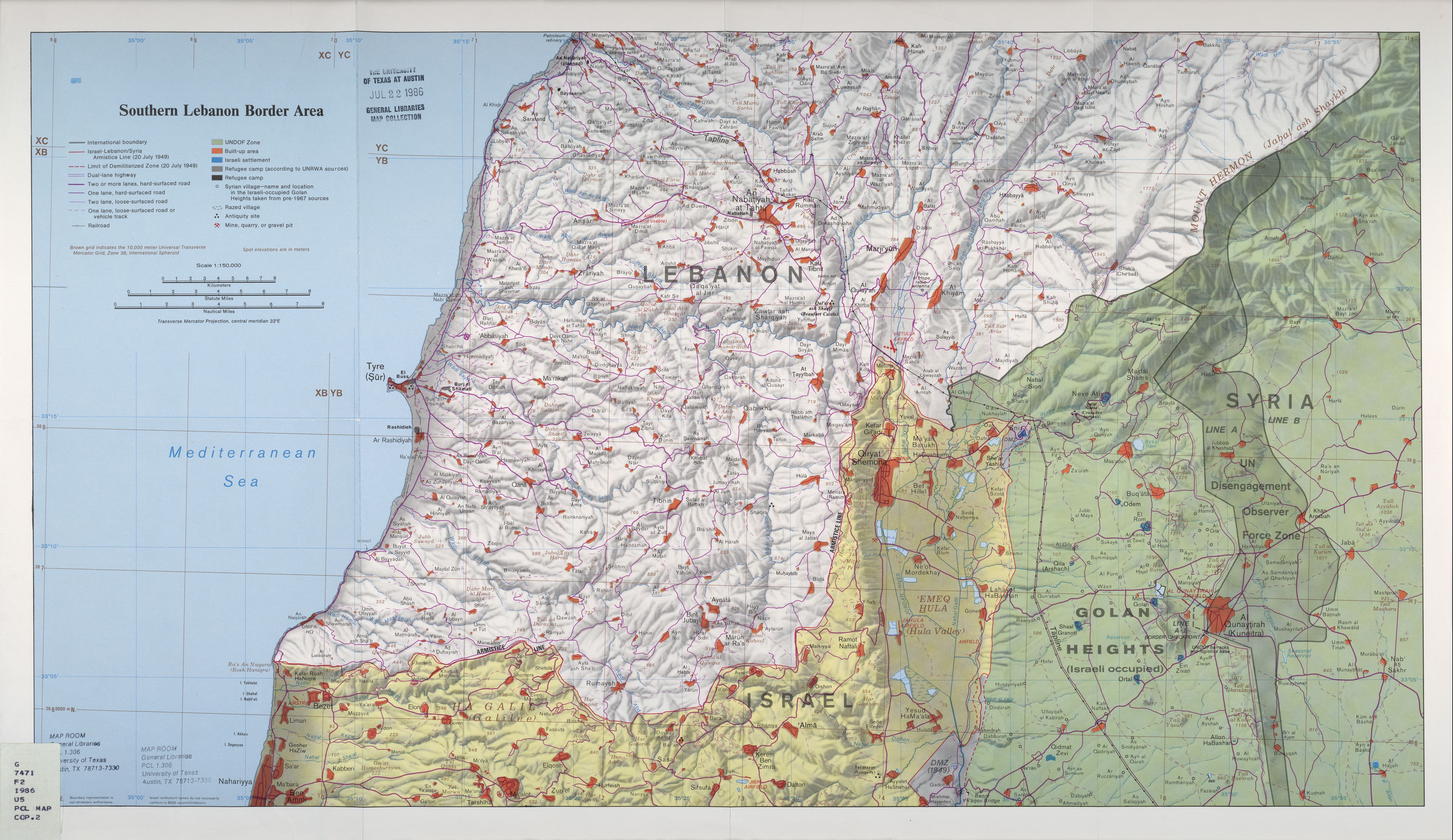
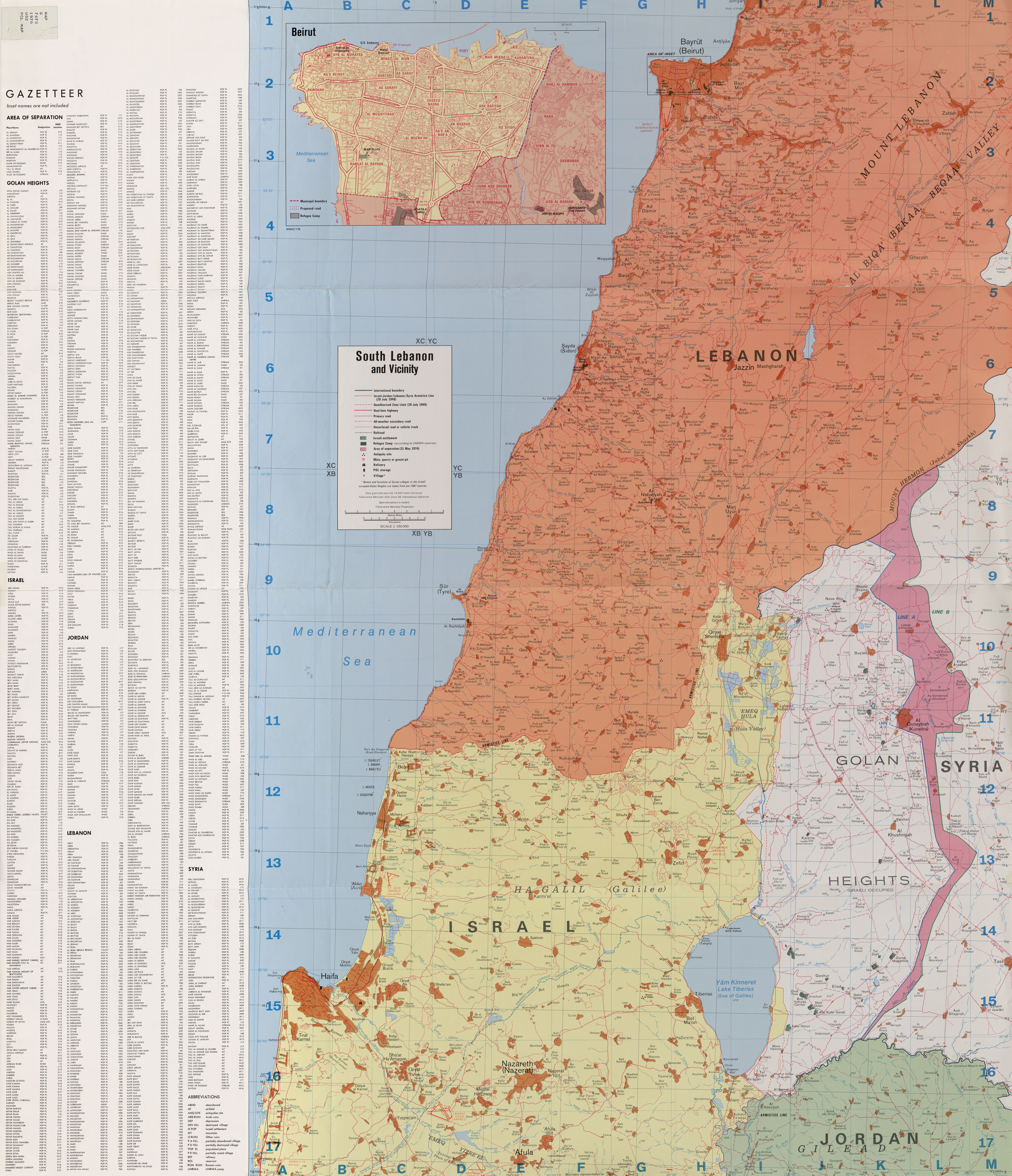
| align="center" | 1226 m<ref name=CIA>''[http://memory.loc.gov/cgi-bin/map_item.pl?data=/home/www/data/gmd/gmd7/g7462/g7462g/ct001957.jp2&style=gmd&itemLink=D?gmd:2:./temp/~ammem_fDHR::&title=Golan%20Heights%20and%20vicinity%20%3a%20October%201994. Golan Heights and vicinity 1994]''</ref><ref name=SouthernLebanonBorderArea>''[http://lib.utexas.edu/maps/middle_east_and_asia/lebanon_southern_border_1986.jpg Southern Lebanon Border Area 1986]''</ref><ref name=SouthLebanonandVicinity>''[http://lib.utexas.edu/maps/middle_east_and_asia/lebanon_south_and_vicinity_1976.jpg South Lebanon and Vicinity 1976]''</ref> |
|||
| align="left" |{{coord|33|12|40|N|35|47|20|E|type:mountain|display=inline}} |
|||
| align="center" | Part of an extinct volcano in the northern Golan Heights. |
|||
|- |
|||
|align="center" |Tall Yusuf/Mount Yosifon ({{lang-ar|تل يوسف}}, ''Tall Yusuf'', {{lang-he|הר יוסיפון}}, ''Har Yosifon'') |
|||
| align="center" | 981 m<ref name=SouthernLebanonBorderArea /><ref name=SouthLebanonandVicinity /><ref name=CIA /> |
|||
| align="left" |{{coord|33|03|24|N|35|47|49|E|type:mountain|display=inline}} |
|||
| align="center" | Part of an extinct volcano in the central Golan Heights. |
|||
|- |
|||
|align="center" |Tell al-Sheikh/Mount Hermonit ({{lang-ar|تل الشيخ}}, ''Tell al-Sheikh''; {{lang-he|הר חרמונית}}, ''Har Hermonit'') |
|||
| align="center" | 1211 m<ref name=SouthernLebanonBorderArea /><ref name=SouthLebanonandVicinity /><ref name=CIA /> |
|||
| align="left" |{{coord|33|10|55|N|35|47|39|E|type:mountain|display=inline}} |
|||
| align="center" | Part of an extinct volcano in the northern Golan Heights. |
|||
|- |
|||
|align="center" |Tel Jukhdar/Givat Orcha ({{lang-ar|تل جوخدار}}, ''Tel Jukhdar'', {{lang-he|גבעת אורחה}}, ''Givat Orcha'') |
|||
| align="center" | 646 m<ref>[http://www.kkl.org.il/kkl/english/main_subject/from%20the%20press/december%202007%20-%20from%20the%20press/new%20road%20connects%20north%20and%20south%20golan.x kkl.org.il]</ref> |
|||
| align="left" |{{coord|32|55|39|N|35|51|09|E|type:mountain|display=inline}} |
|||
| align="center" | Hill in southeastern Golan Heights. |
|||
|- |
|||
|align="center" |Tell Sader al-Arus/Mount Kramim ({{lang-ar|تل صدر العروس}}, ''Tell Sader al-Arus''; {{lang-he|הר כרמים}}, ''Har Kramim'', lit. ''vineyards mountain'') |
|||
| align="center" | 1198 m<ref>Tell Sader al-Arus/Mount Kramim - [http://books.google.com/books?q=%22Mount+Kramim+(Tell+Sader+al-Arus)%22+%221198+m+above+sea+level.%22&spell=1&oi=spell ''Israel and Syria: peace and security on the Golan'']</ref> |
|||
| align="left" |{{coord|33|13|06|N|35|46|32|E|type:mountain|display=inline}} |
|||
| align="center" | Part of an extinct volcano in northern Golan Heights. |
|||
|- |
|||
|align="center" |Tell Saki ({{lang-ar|تل الساقي}}), ''Tell al-Saki''; {{lang-he|תל א-סאקי}}, ''Tell Saki'') |
|||
| align="center" |594 m |
|||
| align="left" |{{coord|32|51|58|N|35|49|50|E|type:mountain|display=inline}} |
|||
| align="center" | Small extinct volcano in southern Golan Heights. |
|||
|- |
|||
|} |
|||
== |
==Pictures== |
||
<center> |
|||
{{coord|33|24|58|N|35|51|27|E|type:mountain|display=inline}} |
|||
<gallery> |
|||
{{main|Mount Hermon}} |
|||
Image:Paras mount.JPG|Tall al-Faras/Mount Peres |
|||
({{lang-ar|جبل الشيخ}}, ''Jabal el-Shaykh'', {{lang-he|הר חרמון}}, ''Har Hermon'') Parts of Mount Hermons southern slopes fall within the Golan Heights. |
|||
Image:Golan 1.JPG|Tall Abu an Nada/Mount Avital |
|||
Image:HarBental WaterReservoirAndMountain.jpg|Tal Al-Gharam/Mount Bental |
|||
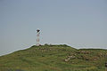
==Mount Hosek== |
|||
Image:Windmillsgolan3.jpg|Tall al Ghassaniyah/Mount Bnei Rasan |
|||
{{coord|33|03|14|N|35|51|01|E|type:mountain|display=inline}} |
|||
Image:MtYosifun.jpg|Tall Yusuf/Mount Yosifon |
|||
Image:Juhader.JPG|Tel Jukhdar/Givat Orcha |
|||
({{lang-he|הר חוזק}}, ''Har Hosek'') is a part of an extinct volcano in the east of the Golan Heights. The top of the mountain is 1158 meters above sea level. |
|||
Image:Hozek.jpg|Mount Hosek |
|||
</gallery> |
|||
==Mount Ram== |
|||
</center> |
|||
{{coord|33|14|43|N|35|47|02|E|type:mountain|display=inline}} |
|||
({{lang-he|הר רם}}, ''Har Ram'', lit. ''High Mountain'') is part of an extinct volcano in the north of the Golan Heights. The top of the mountain is 1188 meters above sea level.<ref>Mount Ram - [http://books.google.com/books?id=-IFtAAAAMAAJ&q=%22mount+Ram%22&dq=%22mount+Ram%22&lr=&cd=18 ''Israel and Syria: peace and security on the Golan'']</ref> |
|||
The mountain is the northernmost in a line of hills. It is 2 km south east of [[Majdal Shams]] and 2 km northeast of the [[crater lake]] [[Lake Ram]]. It offers a good lookout point to Lake Ram. The mountain has two peaks. |
|||
==Mount Shifon== |
|||
{{coord|33|04|10|N|35|46|08|E|type:mountain|display=inline}} |
|||
({{lang-he|הר שיפון}}, ''Har Shifon'') is a part of an extinct volcano in the northeast of the Golan Heights. The top of the mountain is 977 meters above sea level<ref>Mount Shifon - [http://books.google.com/books?id=-IFtAAAAMAAJ&q=%22Mount+Shifon+(977m)%22&dq=%22Mount+Shifon+(977m)%22&cd=1 ''Israel and Syria: peace and security on the Golan''] p. 105.</ref> and around 150 m above the surroundings. It is 1 km south of the [[Israeli settlement]], [[Ortal, Golan Heights|Ortal]]. It is a good observation point for the Golan Heights, the [[Galilee]] and Mount Hermon. |
|||
==Ras al-Ahmar/Mount Odem== |
|||
{{coord|33|11|55|N|35|45|15|E|type:mountain|display=inline}} |
|||
({{lang-ar|رأس الأحمر}}, ''Ras al-Ahmar''; {{lang-he|הר אודם}}, ''Har Odem'', lit. ''ruby mountain'') is a part of an extinct volcano in the north of the Golan Heights. The top of the mountain is 1100 meters above sea level. |
|||
The mountain is within the Odem forest reserve, between the [[Druze]] village [[Mas'ade]] in the north and the [[Israeli settlement]] [[El Rom]] in the south. The origin of the name is the red volcanic earth, also related to the Arabic name, Ras Al-Ahmr ({{lang-ar|رأس الأحمر}}). The mountain had two volcanoes, one in the west and one in the north. The eastern slope is cultivated with grape vineyards. |
|||
==Tall al-Faras/Mount Peres== |
|||
[[File:Paras mount.JPG|thumb|150px|Tall al-Faras/Mount Peres]] |
|||
{{coord|32|57|34|N|35|51|50|E|type:mountain|display=inline}} |
|||
({{lang-ar|تل الفرس}}, ''Tall al-Faras'', {{lang-he|הר פֶּרֶס}}, ''Har Peres'') is a volcanic mountain located in central Golan Heights, some {{convert|5.5|km|mi}} east of the Israeli settlement [[Keshet, Golan Heights|Keshet]]. Its highest point is {{convert|929|m|ft}} above [[sea level]],<ref name=SouthLebanonandVicinity/><ref name=CIA/> or about {{convert|200|m|ft}} above ground level. The mountain is the southernmost of a series of [[dormant volcano]]es that stretch up to the northern parts of the Golan Heights. On top of the mountain is a well-preserved [[volcanic crater|crater]], 200 meters in diameter and {{convert|35|m|ft}} deep. |
|||
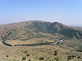
==Tall Abu an Nada/Mount Avital== |
|||
[[File:Golan 1.JPG|thumb|150px|Tall Abu an Nada/Mount Avital]] |
|||
{{Coord|33|06|38|N|35|47|45|E|type:mountain|display=inline}} |
|||
({{lang-ar|تل أبو الندى, ''Tall Abu an Nada''}}, {{lang-he|הר אביטל}}) is part of an extinct volcano in the northeast of the Golan Heights. The peak is 1204 meters above sea level.<ref name=SouthLebanonandVicinity/><ref name=CIA/> |
|||
The mountain is part of a series of hills. To the north is Tal Al-Gharam/Har Bental, with a height of 1171 meters above sea level. The two hills are two craters of a single volcano. Both hills together form the Nature Reserve "Har Avital—Har Bental". The farmland inside the crater is associated with the Israeli settlement, [[El Rom]]. Atop of the mountain is an [[Israel Defense Forces|IDF]] base of the [[Military Intelligence Directorate (Israel)|Aman]]. |
|||
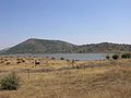
==Tal Al-Gharam/Mount Bental== |
|||
[[File:HarBental WaterReservoirAndMountain.jpg|thumb|150px|Tal Al-Gharam/Mount Bental]] |
|||
{{coord|33|07|45|N|35|47|09|E|type:mountain|display=inline}} |
|||
({{lang-ar|تل الغرام, ''Tal Al-Gharam''}}, {{lang-he|הר בנטל}}, ''Har Bental'') is part of an extinct volcano in the northeastern Golan Heights. The top of the mountain is 1171 metres above sea level. |
|||
The mountain is part of a series of hills. Nearby to the south is Tall Abu Nada/Mount Avital, with a height of 1204 meters above sea level. The two mountains are two craters of a single volcano. Both mountains together form the Nature Reserve "Har Avital - Har Bental". The western slope of the mountain is covered by a dense oak forest. |
|||
The Arabic name means "Lover hill" or "Hill of impassioned love". The mountain is located west of the [[Syria]]n city [[Quneitra]] and south of the Israeli settlement [[Merom Golan]], on its slope. |
|||
On the top of the mountain is the visitor center of the [[Golan Regional Council]] and a reconstructed IDF emplacement (built on the original Syrian emplacement).{{Fact|date=March 2010}} The mountain is an excellent [[lookout]] point towards the rest of Syria in the east, the Mount Hermon slopes in the north, and the southern Golan Heights.{{Fact|date=March 2010}} Near the visitor center is a small [[sculpture garden]] exposing steel sculptures by the Dutch artist "Joop de Jong",<ref>Joop de Jong [http://www.talgallery.co.il/content2.php?actions=show&id=3853&r_id=3851 www.talgallery.co.il]</ref> a member of Merom Golan. |
|||
The name of the restaurant on the top is "Kofi Annan" (hebr. קפה ענן), which means "cloud coffee".<ref>Cloud Coffee [http://www.2eat.co.il/eng/anan/ www.2eat.co.il]</ref> |
|||
At the bottom of the mountain is a huge water reservoir, the "Bental reservoir", built in the 1980s. It is filled by rain water and local creeks (flowing into the rest of Syria and agricultural fields east of the mountain). The red marked hiking trail #1100 leads from the water reservoir to the top of the mountain. |
|||
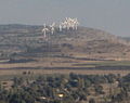
==Tall al Ghassaniyah/Mount Bnei Rasan== |
|||
[[File:Windmillsgolan3.jpg|thumb|150px|Tall al Ghassaniyah/Mount Bnei Rasan]] |
|||
{{coord|33|04|49|N|35|50|04|E|type:mountain|display=inline}} |
|||
({{lang-ar|تلّ الغسانية}}, ''Tall al Ghassaniyah''; {{lang-he|הר בני רסן}}, ''Har Bnei Rasan'') is part of an extinct volcano in the eastern Golan Heights. The mountain peak is {{convert|1072|m|ft|0}} above sea level.<ref name=SouthernLebanonBorderArea /><ref name=SouthLebanonandVicinity /><ref name=CIA /> |
|||
Atop the mountain is the [[Golan Heights Wind Farm]]. It consists of ten wind turbines to produce 600 kW each of electrical energy. They were erected in 1993. The axes are 30 m above ground, the length of the blades (three per generator) is 18 m. Each turbine weights 70 [[Tonne|tons]], a single blade 1200 [[Kilogram|kg]], and the electric generator 30 tons. |
|||
==Tall al Makhfi== |
|||
{{coord|33|08|0|N|35|48|0|E|type:mountain|display=inline}} |
|||
({{lang-ar|تل المخفي}}, ''Tall al Makhfi'') is a mountain in the northeastern Golan Heights, north of [[Quneitra]]. The mountaintop is 1055 meters above sea level.<ref name=SouthernLebanonBorderArea /><ref name=SouthLebanonandVicinity /><ref name=CIA /> |
|||
==Tall Wardah/Mount Varda== |
|||
{{coord|33|12|40|N|35|47|20|E|type:mountain|display=inline}} |
|||
({{lang-ar|تل وردة}}, ''Tall Wardah'', {{lang-he|הר ורדה}}, ''Har Varda'', lit. ''Rose mountain'') is part of an extinct volcano in the northern Golan Heights. The mountaintop is 1226 meters above sea level.<ref name=CIA>''[http://memory.loc.gov/cgi-bin/map_item.pl?data=/home/www/data/gmd/gmd7/g7462/g7462g/ct001957.jp2&style=gmd&itemLink=D?gmd:2:./temp/~ammem_fDHR::&title=Golan%20Heights%20and%20vicinity%20%3a%20October%201994. Golan Heights and vicinity 1994]''</ref><ref name=SouthernLebanonBorderArea>''[http://lib.utexas.edu/maps/middle_east_and_asia/lebanon_southern_border_1986.jpg Southern Lebanon Border Area 1986]''</ref><ref name=SouthLebanonandVicinity>''[http://lib.utexas.edu/maps/middle_east_and_asia/lebanon_south_and_vicinity_1976.jpg South Lebanon and Vicinity 1976]''</ref> |
|||
It is the highest mountain in the Golan Heights (not in the [[Mount Hermon]] area). On the eastern slopes is an abandoned [[tuff]] [[quarry]]. |
|||
==Tall Yusuf/Mount Yosifon== |
|||
[[File:MtYosifun.jpg|thumb|150px|Tall Yusuf/Mount Yosifon]] |
|||
{{coord|33|03|24|N|35|47|49|E|type:mountain|display=inline}} |
|||
({{lang-ar|تل يوسف}}, ''Tall Yusuf'', {{lang-he|הר יוסיפון}}, ''Har Yosifon'') is a part of an extinct volcano in the central Golan Heights. The top of the mountain is 981 meters above sea level.<ref name=SouthernLebanonBorderArea /><ref name=SouthLebanonandVicinity /><ref name=CIA /> |
|||
During the [[Yom Kippur War]], the Israel Defense Forces set up a line of defense that went through the mountain in the battle for the Golan Heights.<ref>[http://www.erichammelbooks.com/books/f_duel-golan.php ''The Reserves Are Coming'', Jerrold S. Asher and Eric Hammel]</ref> |
|||
==Tell al-Sheikh/Mount Hermonit== |
|||
{{coord|33|10|55|N|35|47|39|E|type:mountain|display=inline}} |
|||
({{lang-ar|تل الشيخ}}, ''Tell al-Sheikh''; {{lang-he|הר חרמונית}}, ''Har Hermonit'') is a part of an extinct volcano in the north of the Golan Heights. The top of the mountain is 1211 meters above sea level<ref name=SouthernLebanonBorderArea /><ref name=SouthLebanonandVicinity /><ref name=CIA /> and is the second highest mountain on the Golan Heights, after Tall Wardah/Har Varda. |
|||
The Arabic name of the mountain is derived from the name of Mount Hermon, (Jabel al-Sheikh) ({{lang-ar|جبل الشيخ}}). According to Druze tradition, Tel A-Sheikh is the wife of Jebel A-Sheikh. The Hebrew origin of Hermonit is the female form of Mount Hermon, similarly to the Arabic. Most of Tell al-Sheikh/Har Hermonit is within the [[nature reserve]] of Tel A-Sheikha. |
|||
==Tel Jukhdar/Givat Orcha== |
|||
{{coord|32|55|39|N|35|51|09|E|type:mountain|display=inline}} |
|||
({{lang-ar|تل جوخدار}}, ''Tel Jukhdar'', {{lang-he|גבעת אורחה}}, ''Givat Orcha'') is a hill in the southeast of the Golan Heights. The top of the mountain is 646 meters above sea level.<ref>[http://www.kkl.org.il/kkl/english/main_subject/from%20the%20press/december%202007%20-%20from%20the%20press/new%20road%20connects%20north%20and%20south%20golan.x kkl.org.il]</ref> |
|||
==Tell Sader al-Arus/Mount Kramim== |
|||
{{coord|33|13|06|N|35|46|32|E|type:mountain|display=inline}} |
|||
({{lang-ar|تل صدر العروس}}, ''Tell Sader al-Arus''; {{lang-he|הר כרמים}}, ''Har Kramim'', lit. ''vineyards mountain'') is a part of an extinct volcano in the north of the Golan Heights. The top of the mountain is 1198 meters above sea level.<ref>Tell Sader al-Arus/Mount Kramim - [http://books.google.com/books?q=%22Mount+Kramim+(Tell+Sader+al-Arus)%22+%221198+m+above+sea+level.%22&spell=1&oi=spell ''Israel and Syria: peace and security on the Golan'']</ref> |
|||
It is part of a line of hills between Mount Ram and Tall Wardah/Mount Varda. |
|||
==Tell Saki== |
|||
{{coord|32|51|58|N|35|49|50|E|type:mountain|display=inline}} |
|||
({{lang-ar|تل الساقي}}), ''Tell al-Saki''; {{lang-he|תל א-סאקי}}, ''Tell Saki'') is a small extinct volcano in the south of the Golan Heights. The top of the mountain is 594 meters above sea level. |
|||
==External links== |
|||
* [http://www.kkl.org.il/kkl/english/main_subject/from%20the%20press/december%202007%20-%20from%20the%20press/new%20road%20connects%20north%20and%20south%20golan.x new road connects north and south Golan] KKL. |
|||
* [http://mg-wind.starwebz.com Mey Golan Wind Energy Ltd.] |
|||
==References== |
==References== |
||
Revision as of 23:28, 24 April 2010
Mountains in the Golan Heights.
| Name | Height | Coordinates | Notes |
|---|---|---|---|
| Mount Baron (Hebrew: הר בראון, Har Baron) | 1056 m[1][2] | 33°09′30″N 35°46′43″E / 33.15833°N 35.77861°E | Part of an extinct volcano in the northeastern Golan Heights. |
| Mount Hermon (Arabic: جبل الشيخ, Jabal el-Shaykh, Hebrew: הר חרמון, Har Hermon) | 1,804 m | 33°24′58″N 35°51′27″E / 33.41611°N 35.85750°E | Parts of Mount Hermons southern slopes fall within the northern Golan Heights. |
| Mount Hosek (Hebrew: הר חוזק, Har Hosek) | 1158 m | 33°03′14″N 35°51′01″E / 33.05389°N 35.85028°E | Part of an extinct volcano in the eastern Golan Heights. |
| Mount Ram (Hebrew: הר רם, Har Ram, lit. High Mountain) | 1188 m[3] | 33°14′43″N 35°47′02″E / 33.24528°N 35.78389°E | Part of an extinct volcano in the northern Golan Heights. |
| Mount Shifon (Hebrew: הר שיפון, Har Shifon) | 977 m[4] | 33°04′10″N 35°46′08″E / 33.06944°N 35.76889°E | Part of an extinct volcano in the northeastern the Golan Heights. |
| Ras al-Ahmar/Mount Odem (Arabic: رأس الأحمر, Ras al-Ahmar; Hebrew: הר אודם, Har Odem, lit. ruby mountain) | 1100 m | 33°11′55″N 35°45′15″E / 33.19861°N 35.75417°E | Part of an extinct volcano in the northern Golan Heights. |
| Tall al-Faras/Mount Peres (Arabic: تل الفرس, Tall al-Faras, Hebrew: הר פֶּרֶס, Har Peres) | 929 m[2][5] | 32°57′34″N 35°51′50″E / 32.95944°N 35.86389°E | Volcanic mountain located in central Golan Heights. |
| Tall Abu an Nada/Mount Avital ([تل أبو الندى, Tall Abu an Nada] Error: {{Lang-xx}}: text has italic markup (help), Hebrew: הר אביטל) | 1204 m[2][5] | 33°06′38″N 35°47′45″E / 33.11056°N 35.79583°E | Part of an extinct volcano in the northeastern Golan Heights. |
| Tal Al-Gharam/Mount Bental ([تل الغرام, Tal Al-Gharam] Error: {{Lang-xx}}: text has italic markup (help), Hebrew: הר בנטל, Har Bental) | 1171 m | 33°07′45″N 35°47′09″E / 33.12917°N 35.78583°E | Part of an extinct volcano in the northeastern Golan Heights. |
| Tall al Ghassaniyah/Mount Bnei Rasan (Arabic: تلّ الغسانية, Tall al Ghassaniyah; Hebrew: הר בני רסן, Har Bnei Rasan) | 1072 m[1][2][5] | 33°04′49″N 35°50′04″E / 33.08028°N 35.83444°E | Part of an extinct volcano in the eastern Golan Heights. Atop the mountain is the Golan Heights Wind Farm. |
| Tall al Makhfi (Arabic: تل المخفي, Tall al Makhfi) | 1055 m[1][2][5] | 33°08′0″N 35°48′0″E / 33.13333°N 35.80000°E | Mountain in the northeastern Golan Heights, north of Quneitra. |
| Tall Wardah/Mount Varda (Arabic: تل وردة, Tall Wardah, Hebrew: הר ורדה, Har Varda, lit. Rose mountain) | 1226 m[5][1][2] | 33°12′40″N 35°47′20″E / 33.21111°N 35.78889°E | Part of an extinct volcano in the northern Golan Heights. |
| Tall Yusuf/Mount Yosifon (Arabic: تل يوسف, Tall Yusuf, Hebrew: הר יוסיפון, Har Yosifon) | 981 m[1][2][5] | 33°03′24″N 35°47′49″E / 33.05667°N 35.79694°E | Part of an extinct volcano in the central Golan Heights. |
| Tell al-Sheikh/Mount Hermonit (Arabic: تل الشيخ, Tell al-Sheikh; Hebrew: הר חרמונית, Har Hermonit) | 1211 m[1][2][5] | 33°10′55″N 35°47′39″E / 33.18194°N 35.79417°E | Part of an extinct volcano in the northern Golan Heights. |
| Tel Jukhdar/Givat Orcha (Arabic: تل جوخدار, Tel Jukhdar, Hebrew: גבעת אורחה, Givat Orcha) | 646 m[6] | 32°55′39″N 35°51′09″E / 32.92750°N 35.85250°E | Hill in southeastern Golan Heights. |
| Tell Sader al-Arus/Mount Kramim (Arabic: تل صدر العروس, Tell Sader al-Arus; Hebrew: הר כרמים, Har Kramim, lit. vineyards mountain) | 1198 m[7] | 33°13′06″N 35°46′32″E / 33.21833°N 35.77556°E | Part of an extinct volcano in northern Golan Heights. |
| Tell Saki (Arabic: تل الساقي), Tell al-Saki; Hebrew: תל א-סאקי, Tell Saki) | 594 m | 32°51′58″N 35°49′50″E / 32.86611°N 35.83056°E | Small extinct volcano in southern Golan Heights. |
Pictures
-
 Tall al-Faras/Mount Peres
 -
 Tall Abu an Nada/Mount Avital
 -
 Tal Al-Gharam/Mount Bental
 -
 Tall al Ghassaniyah/Mount Bnei Rasan
 -
 Tall Yusuf/Mount Yosifon
 -
 Tel Jukhdar/Givat Orcha
 -
 Mount Hosek


References
- ^ a b c d e f Southern Lebanon Border Area 1986
- ^ a b c d e f g h South Lebanon and Vicinity 1976
- ^ Mount Ram - Israel and Syria: peace and security on the Golan
- ^ Mount Shifon - Israel and Syria: peace and security on the Golan p. 105.
- ^ a b c d e f g Golan Heights and vicinity 1994
- ^ kkl.org.il
- ^ Tell Sader al-Arus/Mount Kramim - Israel and Syria: peace and security on the Golan
Category:Golan Heights Category:Mountains of Syria Category:Volcanoes of Syria Category:Mountains of Israeli occupied territories Category:Volcanoes of Israeli occupied territories