Content deleted Content added
Breein1007 (talk | contribs) the list includes a mountain in the non-israeli controlled area as well |
Ani medjool (talk | contribs) no concensus for put arabic after hebrew |
||
| Line 12: | Line 12: | ||
|Part of an extinct [[volcano]] in the northeastern Golan Heights. |
|Part of an extinct [[volcano]] in the northeastern Golan Heights. |
||
|- |
|- |
||
|align="center" |[[Mount Hermon]] ({{lang- |
|align="center" |[[Mount Hermon]] ({{lang-ar|جبل الشيخ}}, ''Jabal el-Shaykh'', {{lang-he|הר חרמון}}, ''Har Hermon'') |
||
| align="center" | {{convert|2814|m|ft}}<ref>[http://www.middle-east-online.com/english/?id=15277 middle-east-online.com]</ref> |
| align="center" | {{convert|2814|m|ft}}<ref>[http://www.middle-east-online.com/english/?id=15277 middle-east-online.com]</ref> |
||
| align="left" |{{coord|33|24|58|N|35|51|27|E|type:mountain|display=inline}} |
| align="left" |{{coord|33|24|58|N|35|51|27|E|type:mountain|display=inline}} |
||
| Line 32: | Line 32: | ||
|Part of an extinct volcano in the northeastern the Golan Heights. |
|Part of an extinct volcano in the northeastern the Golan Heights. |
||
|- |
|- |
||
|align="center" |Mount Odem/Ras al-Ahmar ({{lang- |
|align="center" |Mount Odem/Ras al-Ahmar ({{lang-ar|رأس الأحمر}}, ''Ras al-Ahmar''; {{lang-he|הר אודם}}, ''Har Odem'', lit. ''ruby mountain'') |
||
| align="center" | {{convert|1100|m|ft}} |
| align="center" | {{convert|1100|m|ft}} |
||
| align="left" |{{coord|33|11|55|N|35|45|15|E|type:mountain|display=inline}} |
| align="left" |{{coord|33|11|55|N|35|45|15|E|type:mountain|display=inline}} |
||
|Part of an extinct volcano in the northern Golan Heights. |
|Part of an extinct volcano in the northern Golan Heights. |
||
|- |
|- |
||
|align="center" |Mount Peres/Tall al-Faras ({{lang- |
|align="center" |Mount Peres/Tall al-Faras ({{lang-ar|تل الفرس}}, ''Tall al-Faras'', {{lang-he|הר פֶּרֶס}}, ''Har Peres'') |
||
| align="center" | {{convert|929|m|ft}}<ref name=SouthLebanonandVicinity/><ref name=CIA/> |
| align="center" | {{convert|929|m|ft}}<ref name=SouthLebanonandVicinity/><ref name=CIA/> |
||
| align="left" |{{coord|32|57|34|N|35|51|50|E|type:mountain|display=inline}} |
| align="left" |{{coord|32|57|34|N|35|51|50|E|type:mountain|display=inline}} |
||
|Volcanic mountain located in central Golan Heights. |
|Volcanic mountain located in central Golan Heights. |
||
|- |
|- |
||
|align="center" |Mount Avital/Tall Abu an Nada ( |
|align="center" |Mount Avital/Tall Abu an Nada ({{lang-ar|تل أبو الندى, ''Tall Abu an Nada''}}, {{lang-he|הר אביטל}}) |
||
| align="center" | {{convert|1204|m|ft}}<ref name=SouthLebanonandVicinity/><ref name=CIA/> |
| align="center" | {{convert|1204|m|ft}}<ref name=SouthLebanonandVicinity/><ref name=CIA/> |
||
| align="left" |{{Coord|33|06|38|N|35|47|45|E|type:mountain|display=inline}} |
| align="left" |{{Coord|33|06|38|N|35|47|45|E|type:mountain|display=inline}} |
||
|Part of an extinct volcano in the northeastern Golan Heights. |
|Part of an extinct volcano in the northeastern Golan Heights. |
||
|- |
|- |
||
|align="center" |Mount Bental/Tal Al-Gharam ({{lang- |
|align="center" |Mount Bental/Tal Al-Gharam ({{lang-ar|تل الغرام, ''Tal Al-Gharam''}}, {{lang-he|הר בנטל}}, ''Har Bental'') |
||
| align="center" | {{convert|1171|m|ft}} |
| align="center" | {{convert|1171|m|ft}} |
||
| align="left" |{{coord|33|07|45|N|35|47|09|E|type:mountain|display=inline}} |
| align="left" |{{coord|33|07|45|N|35|47|09|E|type:mountain|display=inline}} |
||
|Part of an extinct volcano in the northeastern Golan Heights. |
|Part of an extinct volcano in the northeastern Golan Heights. |
||
|- |
|- |
||
|align="center" |Mount Bnei Rasan/Tall al Ghassaniyah ({{lang- |
|align="center" |Mount Bnei Rasan/Tall al Ghassaniyah ({{lang-ar|تلّ الغسانية}}, ''Tall al Ghassaniyah''; {{lang-he|הר בני רסן}}, ''Har Bnei Rasan'') |
||
| align="center" | {{convert|1072|m|ft}}<ref name=SouthernLebanonBorderArea /><ref name=SouthLebanonandVicinity /><ref name=CIA /> |
| align="center" | {{convert|1072|m|ft}}<ref name=SouthernLebanonBorderArea /><ref name=SouthLebanonandVicinity /><ref name=CIA /> |
||
| align="left" |{{coord|33|04|49|N|35|50|04|E|type:mountain|display=inline}} |
| align="left" |{{coord|33|04|49|N|35|50|04|E|type:mountain|display=inline}} |
||
| Line 62: | Line 62: | ||
|Mountain in the northeastern Golan Heights, north of [[Quneitra]]. |
|Mountain in the northeastern Golan Heights, north of [[Quneitra]]. |
||
|- |
|- |
||
|align="center" |Mount Varda/Tall Wardah ({{lang- |
|align="center" |Mount Varda/Tall Wardah ({{lang-ar|تل وردة}}, ''Tall Wardah'', {{lang-he|הר ורדה}}, ''Har Varda'', lit. ''Rose mountain'') |
||
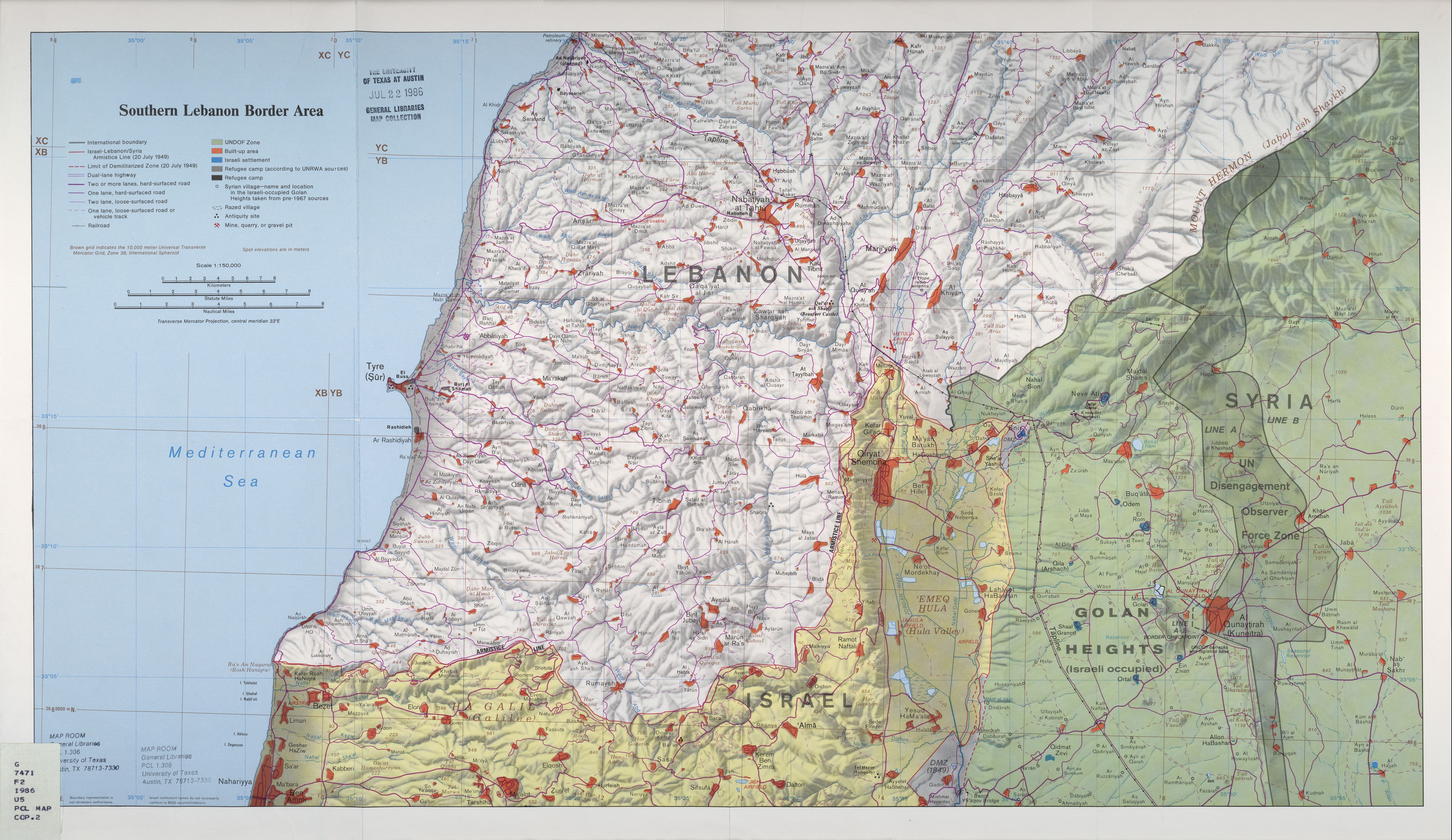
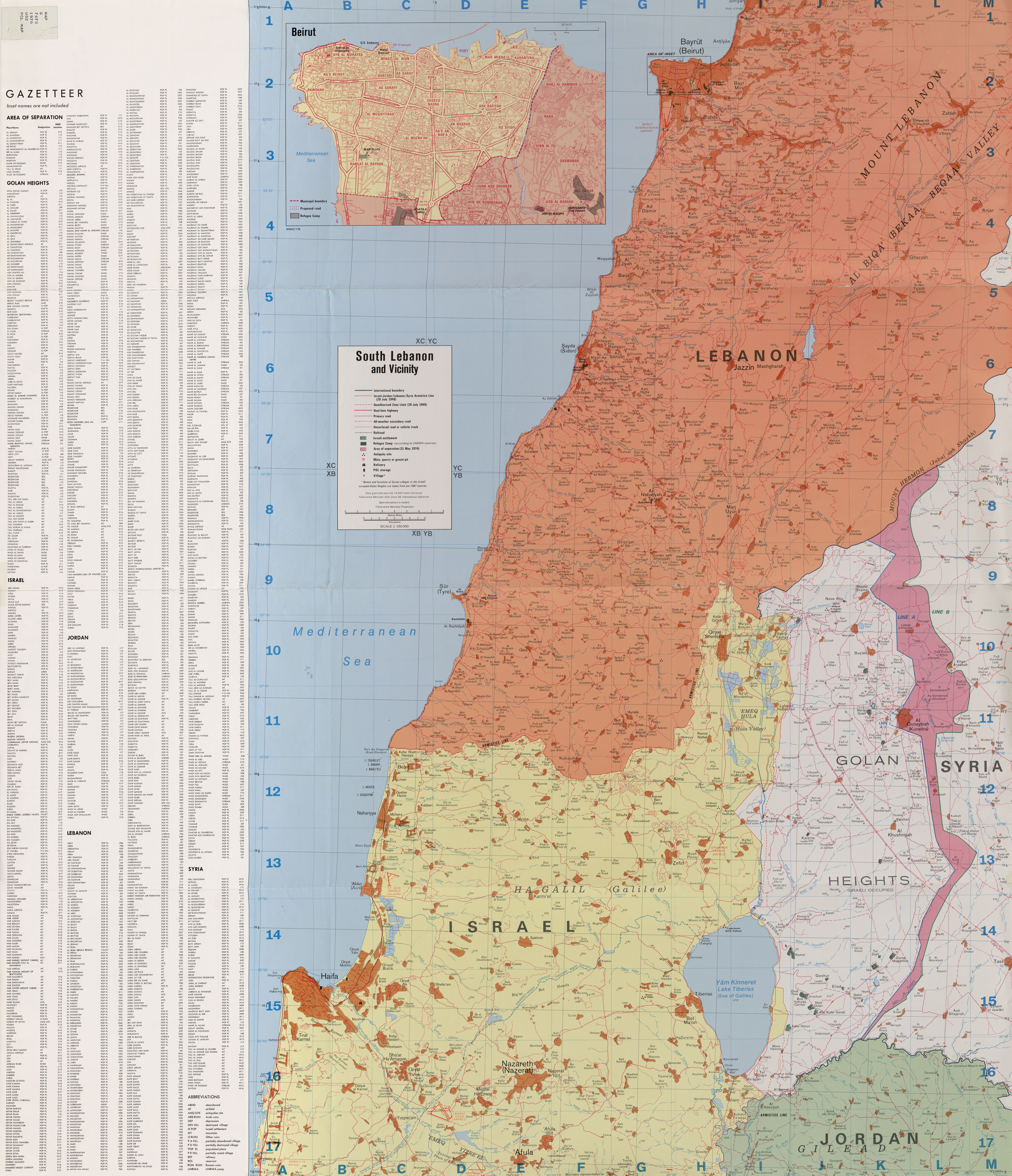
| align="center" | {{convert|1226|m|ft}}<ref name=CIA>''[http://memory.loc.gov/cgi-bin/map_item.pl?data=/home/www/data/gmd/gmd7/g7462/g7462g/ct001957.jp2&style=gmd&itemLink=D?gmd:2:./temp/~ammem_fDHR::&title=Golan%20Heights%20and%20vicinity%20%3a%20October%201994. Golan Heights and vicinity 1994]''</ref><ref name=SouthernLebanonBorderArea>''[http://lib.utexas.edu/maps/middle_east_and_asia/lebanon_southern_border_1986.jpg Southern Lebanon Border Area 1986]''</ref><ref name=SouthLebanonandVicinity>''[http://lib.utexas.edu/maps/middle_east_and_asia/lebanon_south_and_vicinity_1976.jpg South Lebanon and Vicinity 1976]''</ref> |
| align="center" | {{convert|1226|m|ft}}<ref name=CIA>''[http://memory.loc.gov/cgi-bin/map_item.pl?data=/home/www/data/gmd/gmd7/g7462/g7462g/ct001957.jp2&style=gmd&itemLink=D?gmd:2:./temp/~ammem_fDHR::&title=Golan%20Heights%20and%20vicinity%20%3a%20October%201994. Golan Heights and vicinity 1994]''</ref><ref name=SouthernLebanonBorderArea>''[http://lib.utexas.edu/maps/middle_east_and_asia/lebanon_southern_border_1986.jpg Southern Lebanon Border Area 1986]''</ref><ref name=SouthLebanonandVicinity>''[http://lib.utexas.edu/maps/middle_east_and_asia/lebanon_south_and_vicinity_1976.jpg South Lebanon and Vicinity 1976]''</ref> |
||
| align="left" |{{coord|33|12|40|N|35|47|20|E|type:mountain|display=inline}} |
| align="left" |{{coord|33|12|40|N|35|47|20|E|type:mountain|display=inline}} |
||
|Part of an extinct volcano in the northern Golan Heights. |
|Part of an extinct volcano in the northern Golan Heights. |
||
|- |
|- |
||
|align="center" |Mount Yosifon/Tall Yusuf ({{lang- |
|align="center" |Mount Yosifon/Tall Yusuf ({{lang-ar|تل يوسف}}, ''Tall Yusuf'', {{lang-he|הר יוסיפון}}, ''Har Yosifon'') |
||
| align="center" | {{convert|981|m|ft}}<ref name=SouthernLebanonBorderArea /><ref name=SouthLebanonandVicinity /><ref name=CIA /> |
| align="center" | {{convert|981|m|ft}}<ref name=SouthernLebanonBorderArea /><ref name=SouthLebanonandVicinity /><ref name=CIA /> |
||
| align="left" |{{coord|33|03|24|N|35|47|49|E|type:mountain|display=inline}} |
| align="left" |{{coord|33|03|24|N|35|47|49|E|type:mountain|display=inline}} |
||
|Part of an extinct volcano in the central Golan Heights. |
|Part of an extinct volcano in the central Golan Heights. |
||
|- |
|- |
||
|align="center" |Mount Hermonit/Tell al-Sheikh ({{lang- |
|align="center" |Mount Hermonit/Tell al-Sheikh ({{lang-ar|تل الشيخ}}, ''Tell al-Sheikh''; {{lang-he|הר חרמונית}}, ''Har Hermonit'') |
||
| align="center" | {{convert|1211|m|ft}}<ref name=SouthernLebanonBorderArea /><ref name=SouthLebanonandVicinity /><ref name=CIA /> |
| align="center" | {{convert|1211|m|ft}}<ref name=SouthernLebanonBorderArea /><ref name=SouthLebanonandVicinity /><ref name=CIA /> |
||
| align="left" |{{coord|33|10|55|N|35|47|39|E|type:mountain|display=inline}} |
| align="left" |{{coord|33|10|55|N|35|47|39|E|type:mountain|display=inline}} |
||
|Part of an extinct volcano in the northern Golan Heights. |
|Part of an extinct volcano in the northern Golan Heights. |
||
|- |
|- |
||
|align="center" |Givat |
|align="center" |Givat Orcha/Tel Jukhdar ({{lang-ar|تل جوخدار}}, ''Tel Jukhdar'', {{lang-he|גבעת אורחה}}, ''Givat Orcha'') |
||
| align="center" | {{convert|646|m|ft}}<ref>[http://www.kkl.org.il/kkl/english/main_subject/from%20the%20press/december%202007%20-%20from%20the%20press/new%20road%20connects%20north%20and%20south%20golan.x kkl.org.il]</ref> |
| align="center" | {{convert|646|m|ft}}<ref>[http://www.kkl.org.il/kkl/english/main_subject/from%20the%20press/december%202007%20-%20from%20the%20press/new%20road%20connects%20north%20and%20south%20golan.x kkl.org.il]</ref> |
||
| align="left" |{{coord|32|55|39|N|35|51|09|E|type:mountain|display=inline}} |
| align="left" |{{coord|32|55|39|N|35|51|09|E|type:mountain|display=inline}} |
||
|Hill in southeastern Golan Heights. |
|Hill in southeastern Golan Heights. |
||
|- |
|- |
||
|align="center" |Mount Kramim/Tell Sader al-Arus ({{lang- |
|align="center" |Mount Kramim/Tell Sader al-Arus ({{lang-ar|تل صدر العروس}}, ''Tell Sader al-Arus''; {{lang-he|הר כרמים}}, ''Har Kramim'', lit. ''vineyards mountain'') |
||
| align="center" | {{convert|1198|m|ft}}<ref>Tell Sader al-Arus/Mount Kramim - [http://books.google.com/books?q=%22Mount+Kramim+(Tell+Sader+al-Arus)%22+%221198+m+above+sea+level.%22&spell=1&oi=spell ''Israel and Syria: peace and security on the Golan'']</ref> |
| align="center" | {{convert|1198|m|ft}}<ref>Tell Sader al-Arus/Mount Kramim - [http://books.google.com/books?q=%22Mount+Kramim+(Tell+Sader+al-Arus)%22+%221198+m+above+sea+level.%22&spell=1&oi=spell ''Israel and Syria: peace and security on the Golan'']</ref> |
||
| align="left" |{{coord|33|13|06|N|35|46|32|E|type:mountain|display=inline}} |
| align="left" |{{coord|33|13|06|N|35|46|32|E|type:mountain|display=inline}} |
||
|Part of an extinct volcano in northern Golan Heights. |
|Part of an extinct volcano in northern Golan Heights. |
||
|- |
|- |
||
|align="center" |Tell Saki ({{lang- |
|align="center" |Tell Saki ({{lang-ar|تل الساقي}}), ''Tell al-Saki''; {{lang-he|תל א-סאקי}}, ''Tell Saki'') |
||
| align="center" | {{convert|594|m|ft}} |
| align="center" | {{convert|594|m|ft}} |
||
| align="left" |{{coord|32|51|58|N|35|49|50|E|type:mountain|display=inline}} |
| align="left" |{{coord|32|51|58|N|35|49|50|E|type:mountain|display=inline}} |
||
| Line 102: | Line 102: | ||
Image:Windmillsgolan3.jpg|Mount Bnei Rasan/Tall al Ghassaniyah |
Image:Windmillsgolan3.jpg|Mount Bnei Rasan/Tall al Ghassaniyah |
||
Image:MtYosifun.jpg|Mount Yosifon/Tall Yusuf |
Image:MtYosifun.jpg|Mount Yosifon/Tall Yusuf |
||
Image:Juhader.JPG|Givat |
Image:Juhader.JPG|Givat Orcha/Tel Jukhdar |
||
Image:Hozek.jpg|Mount Hosek |
Image:Hozek.jpg|Mount Hosek |
||
</gallery> |
</gallery> |
||
Revision as of 23:18, 28 April 2010
Mountains in the Golan Heights.
| Name | Height | Coordinates | Notes |
|---|---|---|---|
| Mount Baron (Hebrew: הר בראון, Har Baron) | 1,056 metres (3,465 ft)[1][2] | 33°09′30″N 35°46′43″E / 33.15833°N 35.77861°E | Part of an extinct volcano in the northeastern Golan Heights. |
| Mount Hermon (Arabic: جبل الشيخ, Jabal el-Shaykh, Hebrew: הר חרמון, Har Hermon) | 2,814 metres (9,232 ft)[3] | 33°24′58″N 35°51′27″E / 33.41611°N 35.85750°E | Parts of Mount Hermons southern slopes fall within the northern Golan Heights. |
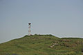
| Mount Hosek (Hebrew: הר חוזק, Har Hosek) | 1,158 metres (3,799 ft) | 33°03′14″N 35°51′01″E / 33.05389°N 35.85028°E | Part of an extinct volcano in the eastern Golan Heights. |
| Mount Ram (Hebrew: הר רם, Har Ram, lit. High Mountain) | 1,188 metres (3,898 ft)[4] | 33°14′43″N 35°47′02″E / 33.24528°N 35.78389°E | Part of an extinct volcano in the northern Golan Heights. |
| Mount Shifon (Hebrew: הר שיפון, Har Shifon) | 977 metres (3,205 ft)[5] | 33°04′10″N 35°46′08″E / 33.06944°N 35.76889°E | Part of an extinct volcano in the northeastern the Golan Heights. |
| Mount Odem/Ras al-Ahmar (Arabic: رأس الأحمر, Ras al-Ahmar; Hebrew: הר אודם, Har Odem, lit. ruby mountain) | 1,100 metres (3,600 ft) | 33°11′55″N 35°45′15″E / 33.19861°N 35.75417°E | Part of an extinct volcano in the northern Golan Heights. |
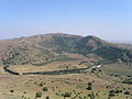
| Mount Peres/Tall al-Faras (Arabic: تل الفرس, Tall al-Faras, Hebrew: הר פֶּרֶס, Har Peres) | 929 metres (3,048 ft)[2][6] | 32°57′34″N 35°51′50″E / 32.95944°N 35.86389°E | Volcanic mountain located in central Golan Heights. |
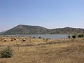
| Mount Avital/Tall Abu an Nada ([تل أبو الندى, Tall Abu an Nada] Error: {{Lang-xx}}: text has italic markup (help), Hebrew: הר אביטל) | 1,204 metres (3,950 ft)[2][6] | 33°06′38″N 35°47′45″E / 33.11056°N 35.79583°E | Part of an extinct volcano in the northeastern Golan Heights. |
| Mount Bental/Tal Al-Gharam ([تل الغرام, Tal Al-Gharam] Error: {{Lang-xx}}: text has italic markup (help), Hebrew: הר בנטל, Har Bental) | 1,171 metres (3,842 ft) | 33°07′45″N 35°47′09″E / 33.12917°N 35.78583°E | Part of an extinct volcano in the northeastern Golan Heights. |
| Mount Bnei Rasan/Tall al Ghassaniyah (Arabic: تلّ الغسانية, Tall al Ghassaniyah; Hebrew: הר בני רסן, Har Bnei Rasan) | 1,072 metres (3,517 ft)[1][2][6] | 33°04′49″N 35°50′04″E / 33.08028°N 35.83444°E | Part of an extinct volcano in the eastern Golan Heights. Atop the mountain is the Golan Heights Wind Farm. |
| Tall al Makhfi (Arabic: تل المخفي, Tall al Makhfi) | 1,055 metres (3,461 ft)[1][2][6] | 33°08′0″N 35°48′0″E / 33.13333°N 35.80000°E | Mountain in the northeastern Golan Heights, north of Quneitra. |
| Mount Varda/Tall Wardah (Arabic: تل وردة, Tall Wardah, Hebrew: הר ורדה, Har Varda, lit. Rose mountain) | 1,226 metres (4,022 ft)[6][1][2] | 33°12′40″N 35°47′20″E / 33.21111°N 35.78889°E | Part of an extinct volcano in the northern Golan Heights. |
| Mount Yosifon/Tall Yusuf (Arabic: تل يوسف, Tall Yusuf, Hebrew: הר יוסיפון, Har Yosifon) | 981 metres (3,219 ft)[1][2][6] | 33°03′24″N 35°47′49″E / 33.05667°N 35.79694°E | Part of an extinct volcano in the central Golan Heights. |
| Mount Hermonit/Tell al-Sheikh (Arabic: تل الشيخ, Tell al-Sheikh; Hebrew: הר חרמונית, Har Hermonit) | 1,211 metres (3,973 ft)[1][2][6] | 33°10′55″N 35°47′39″E / 33.18194°N 35.79417°E | Part of an extinct volcano in the northern Golan Heights. |
| Givat Orcha/Tel Jukhdar (Arabic: تل جوخدار, Tel Jukhdar, Hebrew: גבעת אורחה, Givat Orcha) | 646 metres (2,119 ft)[7] | 32°55′39″N 35°51′09″E / 32.92750°N 35.85250°E | Hill in southeastern Golan Heights. |
| Mount Kramim/Tell Sader al-Arus (Arabic: تل صدر العروس, Tell Sader al-Arus; Hebrew: הר כרמים, Har Kramim, lit. vineyards mountain) | 1,198 metres (3,930 ft)[8] | 33°13′06″N 35°46′32″E / 33.21833°N 35.77556°E | Part of an extinct volcano in northern Golan Heights. |
| Tell Saki (Arabic: تل الساقي), Tell al-Saki; Hebrew: תל א-סאקי, Tell Saki) | 594 metres (1,949 ft) | 32°51′58″N 35°49′50″E / 32.86611°N 35.83056°E | Small extinct volcano in southern Golan Heights. |
Pictures
-
 Mount Peres/Tall al-Faras
 -
 Mount Avital/Tall Abu an Nada
 -
 Mount Bental/Tal Al-Gharam
 -
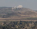 Mount Bnei Rasan/Tall al Ghassaniyah
 -
 Mount Yosifon/Tall Yusuf
 -
 Givat Orcha/Tel Jukhdar
 -
 Mount Hosek


References
- ^ a b c d e f Southern Lebanon Border Area 1986
- ^ a b c d e f g h South Lebanon and Vicinity 1976
- ^ middle-east-online.com
- ^ Mount Ram - Israel and Syria: peace and security on the Golan
- ^ Mount Shifon - Israel and Syria: peace and security on the Golan p. 105.
- ^ a b c d e f g Golan Heights and vicinity 1994
- ^ kkl.org.il
- ^ Tell Sader al-Arus/Mount Kramim - Israel and Syria: peace and security on the Golan