| Category 4 major hurricane (SSHWS/NWS) | |
 Hurricane Octave off the coast of Mexico | |
| Formed | September 8 |
|---|---|
| Dissipated | September 16 |
| Highest winds | 1-minute sustained: 135 mph (215 km/h) |
| Lowest pressure | 948 mbar (hPa); 27.99 inHg |
| Fatalities | None |
| Damage | Minimal |
| Areas affected | California, Arizona |
| Part of the 1989 Pacific hurricane season | |
Hurricane Octave was a Category 4 hurricane that affected California. The remnants of Atlantic Tropical Depression Nine continued drifting westward, and entered the Pacific Ocean on the September 2. It slowly developed, and organized into a tropical depression on September 8. It strengthened into a tropical storm on September 10, thus earning the name Octave . After strengthening into a hurricane the next day, the hurricane started to steadily intensify en route to a peak as a Category 4 hurricane of the Saffir–Simpson Hurricane Scale on September 13. After reaching peak winds of 135 mph (215 km/h), Octave then moved into a region of cooler waters. Octave weakened into a tropical storm on September 14 and a tropical depression the next day before dissipating on September 16. The remnants impacted California and Arizona. Damage was minor, but it did delay the results of a cloud seeding, as well as three weak tornadoes.
Meteorological history

Tropical storm (39–73 mph, 63–118 km/h)
Category 1 (74–95 mph, 119–153 km/h)
Category 2 (96–110 mph, 154–177 km/h)
Category 3 (111–129 mph, 178–208 km/h)
Category 4 (130–156 mph, 209–251 km/h)
Category 5 (≥157 mph, ≥252 km/h)
Unknown
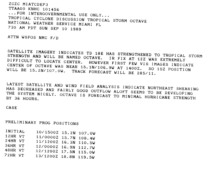
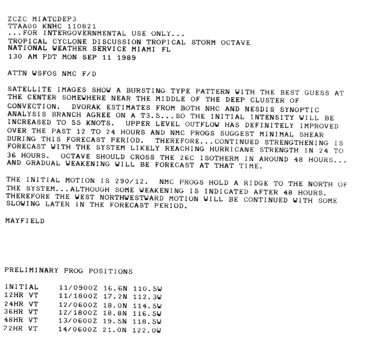
A tropical wave left the African coast on August 21. Moving westward the wave became better organized and became Atlantic Tropical Depression Nine on August 27, but strong wind shear inhibited further development, and the depression degenerated to a tropical wave two days after forming. The wave continued westward and crossed Central America on September 3. After remain stationary for several days, the wave was upgraded to a tropical depression on September 8 about 400 miles (640 km)* south of the Mexican coast. Upon becoming a tropical cyclone, it began to move north becoming a tropical storm the next day as it turned northwestward.[1]
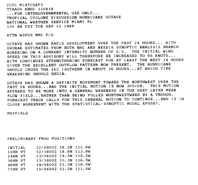
Upon being named, Octave had developed a good outflow, northeast shear was decreasing, and was thus forecast to attain hurricane status.[2] The storm slowly intensified, reaching windspeeds of 65 mph (100 km/h) on September 9, before becoming a hurricane the next day.[1][3] Continuing to intensify, it was soon upgraded to Category 2 intensity. Twelve hours later, during the afternoon of September 13, the NHC reported that Octave had attained winds of 115 mph (185 km/h) and a peak pressure of 954 millibars (Pha).[4] At this time, further intensification was anticipated.[5] Early the next day, the hurricane attained peak intensity as weak Category 4 hurricane based on davorak classifications, a tool used to estimate a tropical cyclones intensity.[6]
Shortly after its peak, the storm over into water temperatures of 26° Celsius (78° Fahrenheit).[1][6] By the end of the 13th the eye had became less defined, and was thus downgraded to a Category 3 intensity. Steady weakening was anticipated as Octave was predicted to turn more towards the west.[7] Continuing to weaken, Octave was downgraded to a category 2 hurricane on the evening of the 13th, and a Category 1 hurricnae the next day as it moved over even cooler water. Shortly thereafter, Octave was downgraded into a tropical storm[1][4] It began to weaken rapidly as it turned west, and was downgraded to a tropical depression late on September 15. After turning back towards the east, Octave rapidly dissipated on the September 16.[1][4]
Preparations and impact
While Octave had no significant effects on land as a hurricane, its remnants did move into California. Effects were limited to minor damage to the grape and raisin crops.[8] In the Sacramento Valley, the town of Redding recorded 2.21 in (56 mm) of rain in a 12 hour span and 3.15 in (80 mm) in 24 hours.[9][10] Sacramento also recorded 1.56 in (40 mm) in 6 hours.[9] A power outage in Lodi, California affected 7,000 costumers.[11] Octave was also responsible for three weak F0 tornadoes.[12][13][14] Light rainfall was reported throughout southern California, with enough falling in Los Angeles to make streets slippery.[15] Moisture associated with Octave produced isolated showers in thunderstorms in parts of southern Arizona on September 16.[16] The unusually heavy rainfall in California was the delayed results of a cloud-seeding operation in southern California and Arizona using the Cloudbuster Icarus. The operation was launched on September 1 but the effects took more than a week to show; the heavy rains were the most seen in California since 1987.[17]
See also
References
- ^ a b c d e Gill Clark (1989-11-09). "Hurricane Octave Preliminary Report". National Hurricane Center. National Oceanic and Atmospheric Administration. p. 1. Retrieved 2010-05-01.
- ^ Robert Case (1989-09-10). "Tropical Storm Octave Discussion 5". National Hurricane Center. National Oceanic and Atmospheric Administration. Retrieved 2010-01-05.
- ^ Max Mayfield (1989-09-06). "Tropical Storm Octave Discussion 8". National Hurricane Center. National Oceanic and Atmospheric Administration. Retrieved 2010-05-01.
- ^ a b c Gill Clark (1989-11-09). "Hurricane Octave Preliminary Report". National Hurricane Center. National Oceanic and Atmospheric Administration. p. 4. Retrieved 2010-05-01.
- ^ Max Mayfield (1989-09-13). "Hurricane Octave Discussion 15". National Hurricane Center. National Oceanic and Atmospheric Administration. Retrieved 2010-05-01.
- ^ a b Jim Gross (1989-09-13). "Hurricane Octave Discussion 17". National Hurricane Center. National Oceanic and Atmospheric Administration. Retrieved 2010-05-01.
- ^ Robert Gross (1989-09-13). "Hurricane Octave Discussion 19". National Hurricane Center. National Oceanic and Atmospheric Administration. Retrieved 2010-05-01.
- ^ Gil Clark (1989-11-09). "Hurricane Octave Preliminary Report". National Hurricane Center. Retrieved 2010-05-01.
{{cite web}}: Unknown parameter|Page=ignored (|page=suggested) (help) - ^ a b Staff Writer (2008-10-07). "Northern California Weather History". Northern California Weather. Retrieved 2010-05-01.
- ^ Associated Press (September 18, 1989). "Storms drench North Carolina". Indiana Gazette.
{{cite news}}:|access-date=requires|url=(help); Italic or bold markup not allowed in:|publisher=(help) - ^ "Storm pounds area". Lodi News-Sentinel. Google News. 1989-09-18. Retrieved 1 May 2010.
- ^ Stuart Hinson (1989). "Event Report for California". National Climatic Data Center. National Oceanic and Atmospheric Administration. Retrieved 2010-05-01.
- ^ Stuart Hinson (1989). "Event Report in California (2)". National Climatic Data Center. National Oceanic and Atmospheric Administration. Retrieved 2010-05-01.
- ^ Stuart Hinson (1989). "Event Report in California (3)". National Climatic Data Center. National Oceanic and Atmospheric Administration. Retrieved 2010-05-01.
- ^ Staff Writer (1989-09-17). "Rain and Storms Affecting Wide Areas". Logansport Pharos-Tribune.
{{cite news}}:|access-date=requires|url=(help); Italic or bold markup not allowed in:|publisher=(help) - ^ Associated Press (1989-09-16). "Octave brings rain to state". Casa Grande Dispatch.
{{cite news}}:|access-date=requires|url=(help); Italic or bold markup not allowed in:|publisher=(help) - ^ James DeMeo (1991). "OROP Arizona 1989: A Cloudbusting Experiment To Bring Rains in the Desert Southwest". Pulse of the Planet. 3 (Summer 1991). Oregon Biophysical Research Lab: 82–92. Retrieved 2010-05-01.
Tropical cyclones of the 1989 Pacific hurricane season | ||
|---|---|---|
 | ||