204.64.0.171 (talk) |
Saline Solutions (talk | contribs) No edit summary |
||
| Line 1: | Line 1: | ||
[[File:Houston Ship Channel Galena.jpg|thumb|right|The Buffalo Bayou portion of the Houston Ship Channel]] |
[[File:Houston Ship Channel Galena.jpg|thumb|right|The Buffalo Bayou portion of the Houston Ship Channel]] |
||
The '''Houston Ship Channel''', located in [[Houston, Texas]], is part of the [[Port of Houston]]—one of the [[United States]]'s busiest [[seaport]]s.<ref name="HGnav">"Welcome to the Houston-Galveston Navigation Channel Project Online Resource Center" (description), [[USACE]], December 2005, webpage: [http://www.swg.usace.army.mil/items/hgnc/ USACE-HGNC].</ref> The [[channel (geography)|channel]] is the conduit for ocean-going vessels between the Houston-area |
The '''Houston Ship Channel''', located in [[Houston, Texas]], is part of the [[Port of Houston]]—one of the [[United States]]'s busiest [[seaport]]s.<ref name="HGnav">"Welcome to the Houston-Galveston Navigation Channel Project Online Resource Center" (description), [[USACE]], December 2005, webpage: [http://www.swg.usace.army.mil/items/hgnc/ USACE-HGNC].</ref> The [[channel (geography)|channel]] is the conduit for ocean-going vessels between the Houston-area terminals and the [[Gulf of Mexico]]. |
||
==Overview== |
==Overview== |
||
Revision as of 18:47, 24 September 2013

The Houston Ship Channel, located in Houston, Texas, is part of the Port of Houston—one of the United States's busiest seaports.[1] The channel is the conduit for ocean-going vessels between the Houston-area terminals and the Gulf of Mexico.
Overview

The channel is a widened and deepened natural watercourse created by dredging the Buffalo Bayou and the Galveston Bay.[2] Major products, such as petrochemicals and Midwestern grain, are transported in bulk together with general cargo. The original watercourse for the channel, Buffalo Bayou, has its headwaters 30 miles (48 km) to the west of the city of Houston. The navigational head of the channel, the most upstream point to which general cargo ships can travel, is at Turning Basin in east Houston.[3]
The Ship Channel has numerous terminals and berthing locations along Buffalo Bayou and Galveston Bay. The major public terminals include Turning Basin, Barbours Cut, and Bayport. There are many private docks as well, including the ExxonMobil Baytown Complex and the Deer Park Complex.[4][5]
The channel, periodically widened and deepened to accommodate ever-larger ships, is 530 feet (160 m) wide by 45 feet (14 m) deep by 50 miles (80 km) long.[1] The islands in the ship channel are part of the ongoing widening and deepening project. The islands are formed from soil pulled up by dredging, and the salt marshes and bird islands are part of the Houston Port Authority's beneficial use and environmental mitigation responsibilities.[1]
The channel has five vehicular crossings. They are the Washburn Tunnel, the Sidney Sherman Bridge, the Sam Houston Ship Channel Bridge, popularly known as the Beltway 8 Bridge; the Fred Hartman Bridge connecting La Porte and Baytown, Texas; and the Lynchburg Ferry.
History

The channel has been used to move goods to the sea since at least 1836. Buffalo Bayou and Galveston Bay were dredged during the late 19th and early 20th centuries to accommodate larger ships. By the mid 1900s the Port of Houston had established itself as the leading port in Texas eclipsing the natural harbors at Galveston and Texas City.[6] The Turning Basin terminal in Harrisburg (now part of Houston) became the port's largest shipping point.
On January 10, 1910, Harris County voted 16-1 to fund dredging the Houston ship channel to a depth of 25 feet (later dredged to a depth of 43–45 feet) for the amount of $1,250,000, which was then matched by federal funds. On June 14, 1914 the first deepwater ship, steamship Satilla arrived at the port of Houston, establishing steamboat service between New York and Houston. On November 10, 1914, President Woodrow Wilson opens the Houston Ship Channel, part of the Port of Houston. The onset of World War I and the first mechanized war's thirst for oil greatly increased use of the ship channel.
The proximity to Texas oilfields led to the establishment of numerous petrochemical refineries along the waterway, such as the ExxonMobil Baytown installation on the eastern bank of the San Jacinto River.
While much of the Ship Channel is associated with heavy industry, two icons of Texas history are also located along its length. The USS Texas (BB-35) saw service during both World Wars, and is the oldest remaining example of a dreadnought-era battleship in existence. The nearby San Jacinto Monument commemorates the Battle of San Jacinto (1836) in which Texas won its independence from Mexico. The US Army's San Jacinto Ordnance Depot was located on the channel from 1941–1964.
The channel was designated a National Civil Engineering Landmark by the American Society of Civil Engineers (ASCE) in 1987.
Pollution
On December 25, 2007, the Houston Ship Channel was featured on the CNN Special, Planet in Peril, as a potential polluter of nearby neighborhoods. That year, the University of Texas released a study suggesting that children living within 2 miles (3.2 km) of the Houston Ship Channel were 56 percent more likely to become sick with leukemia than the national average.[6]
Gallery
-
 Drawing of Ship at Port 1859
 -
 Drawing of Ship at Port 1859
 -
 The Houston Ship Channel during its first opening in 1915.
 -
 Houston Ship Channel and foot of Main Street, Houston, Texas (postcard, circa 1910)
 -
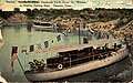 Yachts in the Houston Turning Basin, Houston, Texas (postcard, circa 1911)
 -
 Ship Turning Basin, Buffalo River, Houston, Texas (postcard, circa 1914-1924)
 -
 Cotton on the Ship Channel, Houston, Texas (circa, 1914)


See also
References
- "Houston Ship Channel, Texas". NASA Earth Observatory. Retrieved 2006-05-01.
- ^ "The Houston Ship Channel A History". The Port of Houston Authority. Retrieved 9 September 2009.
- ^ "Turning Basin". Port of Houston Authority. Retrieved 9 Feb 2010.
- ^ "DHR05: HRD for Competitive Advantage: Assignment I". All India Management Association. Retrieved 9 Feb 2010.
- ^ Aslam, Abid (7 Jan 2008). "ENVIRONMENT: U.S. Groups Sue Shell Over Refinery Pollution". Inter Press Service News Agency.
- ^ "Possible Link Between Ship Channel Air Pollutants, Cancer Risks". University of Texas School of Public Health. Retrieved 2009-08-30.
External links
- Houston Ship Channel from the Handbook of Texas Online
- Time-lapse video of a barge navigating a length of the Houston Ship Channel at night
- See historical photographs of the Houston Ship Channel, the Houston community, and more at the University of Houston Digital Library
29°42′30″N 95°00′18″W / 29.70833°N 95.00500°W
| Counties |  | |
|---|---|---|
| "Principal" cities | ||
| Other cities |
For a complete listing, see list of cities and towns in Houston–The Woodlands–Sugar Land MSA | |
| Unincorporated areas | ||
| Bodies of water | ||