OttomanJackson (talk | contribs) m OttomanJackson moved page Hagåtña, Guam to Agana, Guam over redirect: MUCH more common, according to ngrams. |
OttomanJackson (talk | contribs) No edit summary |
||
| Line 15: | Line 15: | ||
|longd=144 |longm=45 |longs=00 |longEW=E |
|longd=144 |longm=45 |longs=00 |longEW=E |
||
|elevation_ft = |
|elevation_ft = |
||
|official_name = |
|official_name = Agana |
||
|other_name = |
|other_name = Hagåtña / Agaña / Aganna |
||
|image_skyline = Hagatna from Fort Apugan.jpg |
|image_skyline = Hagatna from Fort Apugan.jpg |
||
|image_caption = Modern |
|image_caption = Modern Agana as seen from Fort Apugan, which overlooks the town |
||
|image_alt = Skyline view of modern |
|image_alt = Skyline view of modern Agana as seen from Fort Apugan, which overlooks the town |
||
|image_map = Guam map Hagatna.png |
|image_map = Guam map Hagatna.png |
||
|map_caption = Location of |
|map_caption = Location of Agana (Hagåtña) within the Territory of Guam |
||
|area_total_sq_mi = 1 |
|area_total_sq_mi = 1 |
||
|population_total = 1,100 |
|population_total = 1,100 |
||
| Line 32: | Line 32: | ||
|area_code = [[Area code 671|671]] |
|area_code = [[Area code 671|671]] |
||
}} |
}} |
||
''' |
‘’’Agana'''{{IPA-en|əˈɡɑːnjə|}} ‘’’Hagåtña’'' (pronounced {{IPA-ch|həˈɡɑtɲə|}} in Chamorro<ref>http://www.chamorro.com/fino/siudat/siudat.html Chomorro Words pronunciation samples</ref>), [[Spanish language|Spanish]] '''Agaña''', is the capital of the [[Territories of the United States|United States territory]] of [[Guam]]. It is the island's second smallest [[Villages of Guam|village]] in both area and population. From the 18th through mid 20th century, it was Guam's population center. Today, it remains one of the island's major [[commercial district]]s in addition to being the seat of government. |
||
==Etymology== |
==Etymology== |
||
"Hagåt" (also [[romanized]] as ''haga''', with a glottal stop instead of a syllable-final "t") means "blood" in the [[Chamorro language|Chamorro]]/Chamoru language. The suffix "-ña" can be translated as either the possessive pronouns ''his'', ''hers'' or ''its'' in English, or a signification of greater comparative degree, similar to some uses of the English suffix "-er". There is much speculation that the natives originally migrated from the village of Agat/[[Hagåt]]. Therefore, "Hagåtña" can be translated "his or her blood" possibly meaning "related to him, her or it", or it could be translated to what might roughly mean "more Hagåt", as in, an extension of the village of Hagåt. It could also mean "better Hagåt", or "more than, surpassing or superior to Hagåt" in a sense of being "more Hagåt than Hagåt itself". In 1998, the [[Legislature of Guam|Guam Legislature]] changed the name from "Agana" back to the original Chamorro/Chamoru form. However, the name of the neighboring village [[Agana Heights]], remains unchanged. |
"Hagåt" (also [[romanized]] as ''haga''', with a glottal stop instead of a syllable-final "t") means "blood" in the [[Chamorro language|Chamorro]]/Chamoru language. The suffix "-ña" can be translated as either the possessive pronouns ''his'', ''hers'' or ''its'' in English, or a signification of greater comparative degree, similar to some uses of the English suffix "-er". There is much speculation that the natives originally migrated from the village of Agat/[[Hagåt]]. Therefore, "Hagåtña" can be translated "his or her blood" possibly meaning "related to him, her or it", or it could be translated to what might roughly mean "more Hagåt", as in, an extension of the village of Hagåt. It could also mean "better Hagåt", or "more than, surpassing or superior to Hagåt" in a sense of being "more Hagåt than Hagåt itself". In 1998, the [[Legislature of Guam|Guam Legislature]] changed the name from "Agana" back to the original Chamorro/Chamoru form. However, the name of the neighboring village [[Agana Heights]], remains unchanged and Agana is still much more common. |
||
==Geography == |
==Geography == |
||
Agana is located at the mouth of the Agana River on Guam's west coast. According to the [[United States Census Bureau]], the city has a total area of 1 square mile (2.6 km²). The village is bounded by the sandy beaches of Agana Bay to the north, the Agana River and associated wetlands to the east, and a cliff (above which is the village of Agana Heights) to the South. Several high-rise office buildings are in the center of the village, while the western portion of the city known as '''Anigua''' is more residential. Unlike many villages, central Agana is divided into city blocks with shops and small restaurants throughout the center of the village. Highly populated residential areas in the villages of Mongmong-Toto-Maite, Sinajana, and Agana Heights surround Agana. |
|||
== History == |
== History == |
||
{{Unreferenced section|date=February 2009}} |
{{Unreferenced section|date=February 2009}} |
||
[[Image:Guam pre-war.jpg|right|thumb|300px|Photo of Agana taken before World War II.]] |
[[Image:Guam pre-war.jpg|right|thumb|300px|Photo of Agana taken before World War II.]] |
||
Agana was a prominent village before Guam's [[colonization]] by the Spanish. In 1668, the first Spanish [[missionary]], Padre [[San Vitores]] arrived on the island. The family of [[Chief Kepuha]] donated land in Agana enabling San Vitores to build the first church (Dulce Nombre de Maria Cathedral-Basilica) on Guam. |
|||
Under Spanish rule, much of the indigenous population of Guam and other [[Mariana Islands]] was forced to relocate to the city. The remains of buildings from the Spanish administration can be seen in the Plaza |
Under Spanish rule, much of the indigenous population of Guam and other [[Mariana Islands]] was forced to relocate to the city. The remains of buildings from the Spanish administration can be seen in the Plaza of Spain located beside the cathedral of the [[Archdiocese]] of Agana. The remains of the Spanish Governor's Palace is here and is closer to the Department of Education than the Cathedral. |
||
After Guam was ceded by [[Spain]] to the [[United States]] in the [[Spanish-American War]] of 1898, |
After Guam was ceded by [[Spain]] to the [[United States]] in the [[Spanish-American War]] of 1898, Agana remained the seat of government under U.S. Naval Administration. By 1940, the city's population had grown to about 10,000 containing nearly half of the island's residents. |
||
Guam was captured by [[Japan]]ese forces on December 8, 1941. During Guam's 1944 liberation from the Japanese during [[World War II]], the city was heavily damaged by U.S. naval bombardment. Many former residents settled in other parts of Guam after the war. As part of Guam's reconstruction plan, the [[U.S. Navy]] constructed new straight city streets that passed through existing lots and created many plots of land with multiple owners. This has hindered the development of the city to the present day. In December 1944 Guam was the scene of the [[Agana race riot]], between black and white servicemen stationed on the island. |
Guam was captured by [[Japan]]ese forces on December 8, 1941. During Guam's 1944 liberation from the Japanese during [[World War II]], the city was heavily damaged by U.S. naval bombardment. Many former residents settled in other parts of Guam after the war. As part of Guam's reconstruction plan, the [[U.S. Navy]] constructed new straight city streets that passed through existing lots and created many plots of land with multiple owners. This has hindered the development of the city to the present day. In December 1944 Guam was the scene of the [[Agana race riot]], between black and white servicemen stationed on the island. |
||
Today, despite a resident population of only 1,100 (less than 1% of Guam's total), the city remains the seat of the territorial government. Its historic sites are major attractions for visitors. |
Today, despite a resident population of only 1,100 (less than 1% of Guam's total), the city remains the seat of the territorial government. Its historic sites are major attractions for visitors. Agana is served by [[Antonio B. Won Pat International Airport]] in [[Tamuning]] and [[Barrigada]]. |
||
==Culture== |
==Culture== |
||
{{Unreferenced section|date=February 2009}} |
{{Unreferenced section|date=February 2009}} |
||
[[Image:Dulce Nombre de Maria Cathedral Basilica in Hagatna, Guam.jpg|right|200px|thumb|[[Dulce Nombre de Maria Cathedral Basilica]] in |
[[Image:Dulce Nombre de Maria Cathedral Basilica in Hagatna, Guam.jpg|right|200px|thumb|[[Dulce Nombre de Maria Cathedral Basilica]] in Agana, faced by a statue of [[Pope John Paul II]].]] |
||
As Guam's historic population and administrative center, many traditional celebrations take place in |
As Guam's historic population and administrative center, many traditional celebrations take place in Agana. On December 8, [[Blessed Virgin Mary|Santa Marian]] Kamalen, Patroness of the [[Mariana Islands]], is honored by a procession where a statue of the patroness is pulled on a cart amid the prayers of thousands of the island's [[Catholic]]s [http://ns.gov.gu/kamalen.html]. Guam's most celebrated patriotic holiday, Liberation Day is on July 21. The annual Liberation Day Parade takes place on Marine Corps Drive in Agana. In addition to the historic sites at the Plaza of Spain and the Basilica, [[latte stone|Latte Stone]] Park and the Chamorro Village shopping area offer further information about the island's history and culture. |
||
[[Image:Coat of arms of Guam.svg|right|thumb|200px|The seal of Guam depicts Agana Bay]] |
[[Image:Coat of arms of Guam.svg|right|thumb|200px|The seal of Guam depicts Agana Bay]] |
||
| Line 65: | Line 65: | ||
{{Ref improve section|date=February 2009}} |
{{Ref improve section|date=February 2009}} |
||
The island's capital, the [[Legislature of Guam|legislature]], the governor's office and other government offices are located in |
The island's capital, the [[Legislature of Guam|legislature]], the governor's office and other government offices are located in Agana. The Government House ({{lang-ch|Guma I Taotao Guam}}), traditionally the governor's official residence, is situated above the cliff but technically within the city limit of Agana. [[Adelup]], now home of the '''Ricardo J. Bordallo Governor’s Complex''' since 1990, was once part of [[Asan, Guam|Asan-Maina]] before being annexed into Agana so that Agana remains the seat of the Government of Guam. |
||
[[File:Hagatna Post Office.JPG|thumb|left|200px|Hagåtña Post Office]] |
[[File:Hagatna Post Office.JPG|thumb|left|200px|Hagåtña Post Office]] |
||
The [[Guam Department of Corrections]] operates the |
The [[Guam Department of Corrections]] operates the Agana Detention Facility in Agana.<ref>"[http://www.doc.guam.gov/Default.aspx?tabid=3173 Prison Security]." Guam Department of Corrections. Retrieved on May 19, 2010.</ref> |
||
Notable federal government agencies in |
Notable federal government agencies in Agana include the [[District Court of Guam]] at 520 West Soledad Avenue,<ref>"[http://www.gud.uscourts.gov/ District Court of Guam]."</ref> the [[U.S. Attorney for the Districts of Guam and the Northern Mariana Islands|United States Attorney]] at Sirena Plaza, 108 Hernan Cortez, Suite 500,<ref>"[http://www.usdoj.gov/usao/offices/index.html#g United States Attorneys Offices Contact Information]."</ref> and the [[United States Postal Service]] Post Office at 223 West Chalan Santo Papa.<ref>"[http://usps.whitepages.com/service/post_office/16257?p=2&s=gu&service_name=post_office&z=dededo Post Office Location - HAGATNA]." ''[[United States Postal Service]]''. Retrieved on December 4, 2008.</ref> |
||
{{Clear}} |
{{Clear}} |
||
| Line 78: | Line 78: | ||
The [[Guam Public School System]] serves the entire island of Guam. |
The [[Guam Public School System]] serves the entire island of Guam. |
||
Agana residents are zoned to: |
|||
*Carlos L. Taitano Elementary School ([[Sinajana]]) |
*Carlos L. Taitano Elementary School ([[Sinajana]]) |
||
*Jose L. G. Rios Middle School ([[Piti, Guam|Piti]]) |
*Jose L. G. Rios Middle School ([[Piti, Guam|Piti]]) |
||
| Line 84: | Line 84: | ||
====Private schools==== |
====Private schools==== |
||
Private schools in |
Private schools in Agana include: |
||
*[[Academy of Our Lady of Guam]] (Catholic girls' high school located in |
*[[Academy of Our Lady of Guam]] (Catholic girls' high school located in Agana) |
||
===Public libraries=== |
===Public libraries=== |
||
[[File:Nieves M. Flores Memorial Library.JPG|thumb|Nieves M. Flores Memorial Library]] |
[[File:Nieves M. Flores Memorial Library.JPG|thumb|Nieves M. Flores Memorial Library]] |
||
[[Guam Public Library System]] operates the Nieves M. Flores Memorial Library at 254 Martyr Street in |
[[Guam Public Library System]] operates the Nieves M. Flores Memorial Library at 254 Martyr Street in Agana.<ref>http://gpls.guam.gov/Portals/50/GPLS_LOC/GPLS_Location_2007Apr12.xml</ref> |
||
==Notable residents== |
==Notable residents== |
||
| Line 96: | Line 96: | ||
==Gallery== |
==Gallery== |
||
<gallery> |
<gallery> |
||
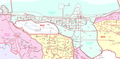
File:HagatnaMap.PNG|Map of |
File:HagatnaMap.PNG|Map of Agana |
||
</gallery> |
</gallery> |
||
Revision as of 22:50, 17 April 2012
Agana
Hagåtña / Agaña / Aganna | |
|---|---|
 Modern Agana as seen from Fort Apugan, which overlooks the town | |
 Location of Agana (Hagåtña) within the Territory of Guam | |
| Country | United States |
| Territory | Guam |
| Government | |
| • Mayor | John A. Cruz |
| Area | |
| • Total | 1 sq mi (3 km2) |
| Population (2000 [1]) | |
| • Total | 1,100 |
| Time zone | UTC+10 (ChST) |
| ZIP codes | 96910, 96932 (PO Box) |
| Area code | 671 |
‘’’Agana'/əˈɡɑːnjə/ ‘’’Hagåtña’ (pronounced Template:IPA-ch in Chamorro[1]), Spanish Agaña, is the capital of the United States territory of Guam. It is the island's second smallest village in both area and population. From the 18th through mid 20th century, it was Guam's population center. Today, it remains one of the island's major commercial districts in addition to being the seat of government.
Etymology
"Hagåt" (also romanized as haga', with a glottal stop instead of a syllable-final "t") means "blood" in the Chamorro/Chamoru language. The suffix "-ña" can be translated as either the possessive pronouns his, hers or its in English, or a signification of greater comparative degree, similar to some uses of the English suffix "-er". There is much speculation that the natives originally migrated from the village of Agat/Hagåt. Therefore, "Hagåtña" can be translated "his or her blood" possibly meaning "related to him, her or it", or it could be translated to what might roughly mean "more Hagåt", as in, an extension of the village of Hagåt. It could also mean "better Hagåt", or "more than, surpassing or superior to Hagåt" in a sense of being "more Hagåt than Hagåt itself". In 1998, the Guam Legislature changed the name from "Agana" back to the original Chamorro/Chamoru form. However, the name of the neighboring village Agana Heights, remains unchanged and Agana is still much more common.
Geography
Agana is located at the mouth of the Agana River on Guam's west coast. According to the United States Census Bureau, the city has a total area of 1 square mile (2.6 km²). The village is bounded by the sandy beaches of Agana Bay to the north, the Agana River and associated wetlands to the east, and a cliff (above which is the village of Agana Heights) to the South. Several high-rise office buildings are in the center of the village, while the western portion of the city known as Anigua is more residential. Unlike many villages, central Agana is divided into city blocks with shops and small restaurants throughout the center of the village. Highly populated residential areas in the villages of Mongmong-Toto-Maite, Sinajana, and Agana Heights surround Agana.
History

Agana was a prominent village before Guam's colonization by the Spanish. In 1668, the first Spanish missionary, Padre San Vitores arrived on the island. The family of Chief Kepuha donated land in Agana enabling San Vitores to build the first church (Dulce Nombre de Maria Cathedral-Basilica) on Guam.
Under Spanish rule, much of the indigenous population of Guam and other Mariana Islands was forced to relocate to the city. The remains of buildings from the Spanish administration can be seen in the Plaza of Spain located beside the cathedral of the Archdiocese of Agana. The remains of the Spanish Governor's Palace is here and is closer to the Department of Education than the Cathedral.
After Guam was ceded by Spain to the United States in the Spanish-American War of 1898, Agana remained the seat of government under U.S. Naval Administration. By 1940, the city's population had grown to about 10,000 containing nearly half of the island's residents.
Guam was captured by Japanese forces on December 8, 1941. During Guam's 1944 liberation from the Japanese during World War II, the city was heavily damaged by U.S. naval bombardment. Many former residents settled in other parts of Guam after the war. As part of Guam's reconstruction plan, the U.S. Navy constructed new straight city streets that passed through existing lots and created many plots of land with multiple owners. This has hindered the development of the city to the present day. In December 1944 Guam was the scene of the Agana race riot, between black and white servicemen stationed on the island.
Today, despite a resident population of only 1,100 (less than 1% of Guam's total), the city remains the seat of the territorial government. Its historic sites are major attractions for visitors. Agana is served by Antonio B. Won Pat International Airport in Tamuning and Barrigada.
Culture

As Guam's historic population and administrative center, many traditional celebrations take place in Agana. On December 8, Santa Marian Kamalen, Patroness of the Mariana Islands, is honored by a procession where a statue of the patroness is pulled on a cart amid the prayers of thousands of the island's Catholics [2]. Guam's most celebrated patriotic holiday, Liberation Day is on July 21. The annual Liberation Day Parade takes place on Marine Corps Drive in Agana. In addition to the historic sites at the Plaza of Spain and the Basilica, Latte Stone Park and the Chamorro Village shopping area offer further information about the island's history and culture.

Diplomatic missions
The Taipei Economic and Cultural Office, of the Republic of China (Taiwan), is located in Suite 505 of the Bank of Guam Building.[2]
Infrastructure and government
The island's capital, the legislature, the governor's office and other government offices are located in Agana. The Government House (Chamorro: Guma I Taotao Guam), traditionally the governor's official residence, is situated above the cliff but technically within the city limit of Agana. Adelup, now home of the Ricardo J. Bordallo Governor’s Complex since 1990, was once part of Asan-Maina before being annexed into Agana so that Agana remains the seat of the Government of Guam.

The Guam Department of Corrections operates the Agana Detention Facility in Agana.[3]
Notable federal government agencies in Agana include the District Court of Guam at 520 West Soledad Avenue,[4] the United States Attorney at Sirena Plaza, 108 Hernan Cortez, Suite 500,[5] and the United States Postal Service Post Office at 223 West Chalan Santo Papa.[6]
Education
Primary and secondary schools
Public schools
The Guam Public School System serves the entire island of Guam.
Agana residents are zoned to:
- Carlos L. Taitano Elementary School (Sinajana)
- Jose L. G. Rios Middle School (Piti)
- John F. Kennedy High School (Tamuning)[7]
Private schools
Private schools in Agana include:
- Academy of Our Lady of Guam (Catholic girls' high school located in Agana)
Public libraries

Guam Public Library System operates the Nieves M. Flores Memorial Library at 254 Martyr Street in Agana.[8]
Notable residents
- Venancio Roberto, two-day Governor of Guam.[9]
Gallery
-
 Map of Agana

References
- ^ http://www.chamorro.com/fino/siudat/siudat.html Chomorro Words pronunciation samples
- ^ "Contact Us." Taipei Economic and Cultural Office Los Angeles. Retrieved on February 4, 2009.
- ^ "Prison Security." Guam Department of Corrections. Retrieved on May 19, 2010.
- ^ "District Court of Guam."
- ^ "United States Attorneys Offices Contact Information."
- ^ "Post Office Location - HAGATNA." United States Postal Service. Retrieved on December 4, 2008.
- ^ http://web.archive.org/web/20060222192437/http://www.lk4kids.com/school+links.htm
- ^ http://gpls.guam.gov/Portals/50/GPLS_LOC/GPLS_Location_2007Apr12.xml
- ^ Leon-Guerrero, Jillette (9 August 2010). "Guam Leaders from 1899-1904". Guampedia. Guam: University of Guam. Archived from the original on 20 October 2010. Retrieved 21 October 2010.
- Rogers, Robert F (1995). Destiny's Landfall: A History of Guam: University of Hawai'i Press. ISBN 0-8248-1678-1
- Carter, Lee D; Carter, Rosa Roberto; Wuerch, William L (1997). Guam History: Perspectives Volume One: MARC. ISBN 1-878453-28-9
- Sanchez, Pedro C. Guahan, Guam: The History of our Island: Sanchez Publishing House.
- (1996) Kinalamten Pulitikat: Sinenten I Chamorro: Issues in Guam's Political Development: The Chamorro Perspective: The Political Status Education Coordinating Commission. ISBN 1-883488-03-6
External links
- Guampedia, Guam's Online Encyclopedia Hagåtña Village
- Hagåtña Guam at Guam Portal
- City of Hagåtña - Government of Guam
- Virtual Hagåtña