EdSomerset (talk | contribs) No edit summary |
EdSomerset (talk | contribs) No edit summary |
||
| Line 11: | Line 11: | ||
{{Mtnbox finish}} |
{{Mtnbox finish}} |
||
'''Dunkery Beacon''' is the highest hill on [[Exmoor]], south-western [[England]], and the highest point in [[Somerset]]. It lies just four [[mile]]s from the [[Bristol Channel]] at [[Porlock]]. The shortest route of ascent goes from the [[car park]] at Dunkery Gate, and is just 1.2 [[kilometre|km]] long. There are extensive views from the summit, including both the [[Bristol Channel|Bristol]] and [[English Channel]] coasts, the [[Brecon Beacons]], [[Bodmin Moor]], [[Dartmoor]], the [[Severn Bridge]]s and [[Cleeve Hill]] 86 miles away in [[Gloucestershire]]. The hill is blanketed in heather and in the summer this gives it a deep purple colour. Ling and bell heather, gorse, sessile oak, ash, hazel and bracken all grow here or in surrounding woodland. Exmoor ponies, red deer, snipes, skylarks and kestrels are some of the fauna to be found here. Dunkery Beacon was given to the [[National Trust for Places of Historic Interest or Natural Beauty|National Trust]] in 1935 by Sir Thomas Ackland, Colonel Wiggin and Allan Hughes along with the rest of the [[Holnicote Estate]] an event commemorated by the summit memorial [[cairn]]. There are several [[Bronze Age]] [[burial mound]]s at or near the summit, two of the larger ones are Joaney How and Robin How. Dunkery is composed of [[Devonian sedimentary]] rock, as can be seen in the red soil. |
'''Dunkery Beacon''' is the highest hill on [[Exmoor]], south-western [[England]], and the highest point in [[Somerset]]. It lies just four [[mile]]s from the [[Bristol Channel]] at [[Porlock]]. The shortest route of ascent goes from the [[car park]] at Dunkery Gate, and is just 1.2 [[kilometre|km]] long. There are extensive views from the summit, including both the [[Bristol Channel|Bristol]] and [[English Channel]] coasts, the [[Brecon Beacons]], [[Bodmin Moor]], [[Dartmoor]], the [[Severn Bridge]]s and [[Cleeve Hill]] 86 miles away in [[Gloucestershire]]. The hill is blanketed in heather and in the summer this gives it a deep purple colour. Ling and bell heather, gorse, sessile oak, ash, hazel and bracken all grow here or in surrounding woodland. Exmoor ponies, red deer, snipes, skylarks and kestrels are some of the fauna to be found here. Dunkery Beacon was given to the [[National Trust for Places of Historic Interest or Natural Beauty|National Trust]] in 1935 by Sir Thomas Ackland, Colonel Wiggin and Allan Hughes along with the rest of the [[Holnicote Estate]] an event commemorated by the summit memorial [[cairn]]. There are several [[Bronze Age]] [[burial mound]]s at or near the summit, two of the larger ones are Joaney How and Robin How. Dunkery is composed of [[Devonian]] [[sedimentary]] rock, as can be seen in the red soil. |
||
==Trivia== |
|||
Although the highest <i>geographical</i> point in Somerset, the tip of the [[Mendip TV Mast]] is higher above sea level at 1924 feet (586 metres). |
|||
Based on the formula 'distance of hill from its nearest higher neighbour in km squared, multiplied by its height in metres', Dunkery is ranked 23rd in the UK in terms of dominance. |
|||
==Gallery== |
==Gallery== |
||
Revision as of 18:41, 17 September 2006
Template:Mtnbox start norange Template:Mtnbox prom Template:Mtnbox topo Template:Mtnbox UK Template:Mtnbox finish
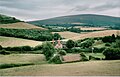
Dunkery Beacon is the highest hill on Exmoor, south-western England, and the highest point in Somerset. It lies just four miles from the Bristol Channel at Porlock. The shortest route of ascent goes from the car park at Dunkery Gate, and is just 1.2 km long. There are extensive views from the summit, including both the Bristol and English Channel coasts, the Brecon Beacons, Bodmin Moor, Dartmoor, the Severn Bridges and Cleeve Hill 86 miles away in Gloucestershire. The hill is blanketed in heather and in the summer this gives it a deep purple colour. Ling and bell heather, gorse, sessile oak, ash, hazel and bracken all grow here or in surrounding woodland. Exmoor ponies, red deer, snipes, skylarks and kestrels are some of the fauna to be found here. Dunkery Beacon was given to the National Trust in 1935 by Sir Thomas Ackland, Colonel Wiggin and Allan Hughes along with the rest of the Holnicote Estate an event commemorated by the summit memorial cairn. There are several Bronze Age burial mounds at or near the summit, two of the larger ones are Joaney How and Robin How. Dunkery is composed of Devonian sedimentary rock, as can be seen in the red soil.
Trivia
Although the highest geographical point in Somerset, the tip of the Mendip TV Mast is higher above sea level at 1924 feet (586 metres). Based on the formula 'distance of hill from its nearest higher neighbour in km squared, multiplied by its height in metres', Dunkery is ranked 23rd in the UK in terms of dominance.
Gallery
-
 The National Trust plaque on the summit
 -
 Dunkery Hill
 -
 Heather in flower on Dunkery Beacon


External link
- Computer generated summit panorama Dunkery Beacon index