rv removal of sources and gross missinterpretation of other. kept Boldwin's edit |
|||
| Line 3: | Line 3: | ||
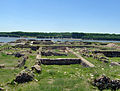
[[File:Capidava.jpg|thumb|right|text-top|upright=1.5|Ruins of the fortress Capidava, modern Romania]] |
[[File:Capidava.jpg|thumb|right|text-top|upright=1.5|Ruins of the fortress Capidava, modern Romania]] |
||
'''Capidava''' (''Kapidaua'', ''Cappidava'', ''Capidapa'', ''Calidava''{{sfn|Tabula Peutingeriana|loc=Segmentum VIII,3}}, ''Calidaua''{{sfn|Tabula Peutingeriana|loc=Segmentum VIII,3}}) was an |
'''Capidava''' (''Kapidaua'', ''Cappidava'', ''Capidapa'', ''Calidava''{{sfn|Tabula Peutingeriana|loc=Segmentum VIII,3}}, ''Calidaua''{{sfn|Tabula Peutingeriana|loc=Segmentum VIII,3}}) was an [[Roman Empire|Roman]] civil and military center on the Lower [[Danube]]{{sfn|Doruțiu-Boilă|1980|p=30}}, in the the [[Roman province|province]] of [[Moesia Inferior]] (later [[Scythia Minor]]), modern [[Dobruja]]. |
||
It is located in the [[village]] with the same name, ''[[Capidava, Constanţa|Capidava]]'', in [[Constanţa County]], [[Romania]]. |
It is located in the [[village]] with the same name, ''[[Capidava, Constanţa|Capidava]]'', in [[Constanţa County]], [[Romania]]. |
||
| Line 12: | Line 12: | ||
=== Tabula Peutingeriana === |
=== Tabula Peutingeriana === |
||
Capidava is depicted in the form ''Calidava''/''Calidaua'' in Segmentum VIII of [[Tabula Peutingeriana]] ( |
Capidava is depicted in the form ''Calidava''/''Calidaua'' in Segmentum VIII of [[Tabula Peutingeriana]] (1st–4th century) on a [[Roman road]] between [[Axiopolis]] and [[Carsium]].{{sfn|Tabula Peutingeriana|loc=Segmentum VIII,3}}{{sfn|Olteanu|loc=Toponyms}} The map provides accurate data on the distances between Axiopolis, Capidava and Carsium. These distances coincide with the distances between the present localities of [[Hinog]] - [[Capidava, Constanţa|Capidava]] and Capidava - [[Hârşova]]. This is also verified by the discovery of a [[milestone]] at [[Seimenii Mici, Constanţa|Seimenii Mici]] that indicates the distance of 18,000 feet (27 km) from Axiopolis to Capidava.{{sfn|Capidava cIMeC}} |
||
[[File:Notitia Dignitatum - Dux Scythiae.jpg|thumb|left|100px||Capidava on [[Notitia Dignitatum]], Dux Scythiae]] |
[[File:Notitia Dignitatum - Dux Scythiae.jpg|thumb|left|100px||Capidava on [[Notitia Dignitatum]], Dux Scythiae]] |
||
| Line 23: | Line 23: | ||
{{See also|Dava (Dacian)}} |
{{See also|Dava (Dacian)}} |
||
Capidava took its name from the old Getic dava ‘settlement” that was in a close area. {{sfn| Florescu | Miclea |1980|p=135}} |
|||
Capidava name has the characteristic Dacian ending, the suffix –dava meaning "settlement, village, town".{{sfn|Polome |1982|p=886}} This [[Getic]] toponym, means the "curve fortified settlement".{{sfn|Capidava cIMeC}} |
Capidava name has the characteristic Dacian ending, the suffix –dava meaning "settlement, village, town".{{sfn|Polome |1982|p=886}} This [[Getic]] toponym, means the "curve fortified settlement".{{sfn|Capidava cIMeC}} |
||
== History == |
== History == |
||
=== |
=== Pre-Roman settlement === |
||
[[File:CapidavaMarkers.JPG|thumb|right|Pottery markers found at Capidava, in display at the [[Constanţa Museum of National History]], Romania.]] |
[[File:CapidavaMarkers.JPG|thumb|right|Pottery markers found at Capidava, in display at the [[Constanţa Museum of National History]], Romania.]] |
||
{{Expand section|date=February 2011}} |
{{Expand section|date=February 2011}} |
||
| ⚫ | |||
| ⚫ | The early 20th century [[Romanians|Romanian]] archaeologist and historian [[Vasile Pârvan]] claimed Capidava was the center of power for the Getic king [[Dapyx]], within a ''territorium Capidavense''.{{sfn|Pârvan|1982|pp=54-55}}{{sfn|Capidava Archaeology}} [[Cassius Dio]]'s [[Historia Romana]] makes mention of the retreat of Dapyx into his fort after his defeat in [[28 BC]] at the hand of [[Marcus Licinius Crassus Dives (consul 30 BC)|Crassus]].{{sfn|Capidava Archaeology|loc=Toponyms}}{{sfn|Cassius Dio|200 AD|loc=LI, 26, 1-4}} Pârvan identified the fort mentioned by Dio with future Roman fort Capidava{{sfn|Pârvan|1926|pp=85-89}}, stating the locations described in the ancient source fit well with the modern location.{{sfn|Pârvan|1926|p=89}}. |
||
The Getic toponym of Capidava confirms a pre-Roman dwelling, while the special geographic position explains the significance of the local settlement, a place that made possible the communication between the Dacians in Dobruja and those in the [[Wallachian Plain]].{{sfn|Capidava cIMeC}} |
|||
Following the claim of Pârvan, many historians supposed a pre-Roman dwelling on the spot of the Roman fort.{{sfn|Pârvan|1982|pp=54-55}}{{sfn|Capidava Archaeology}}{{sfn|Capidava cIMeC}} {{sfn| Pop | Bolovan | Andea |2006|p=112| ”Many, even the initially indigenous centers developed due to the presence of the Roman army. Besides those already mentioned, there were also Halmrys, Salsovia, Capidava and Arrubium”}} {{sfn| Pippidi | 1976 |p=288| ' construcţia de numeroase castre, pe locurile unor vechi aşezări geto- dacice, (Sucidava, Capidava…' i.e. building numerous castru on the place of the old Geto-Dacian settlements (Sucidava, Capidava… }} The geographic position would have explained the significance of the local settlement, a place that made possible the communication between the Dacians in Dobruja and those in the [[Wallachian Plain]].{{sfn|Capidava cIMeC}} However, as of the the first decade of the 2000's, the supposed Getic fort was not archaeologically identified.{{sfn|Capidava Archaeology}} Moreover, in the cemetery excavated at Capidava only graves of specific Roman provincial type were found.<ref>{{cite book |last1=Petculescu |first1=Liviu |editor1-first=Bekker-Nielsen|editor1-last=Tønnes |title=Rome and the Black Sea region |series=Black Sea Studies |volume=5 |year=2006 |publisher=[[Aarhus University]] Press |isbn=8779341748|page=36|chapter=The Roman Army as a Factor of Romanisation in the North-Eastern Part of Moesia Inferior}}</ref> |
|||
| ⚫ | The [[Romanians|Romanian]] archaeologist and historian [[Vasile Pârvan]] |
||
Pârvan identified the administrative form of Capidava as an old Dacian [[pagus]], based on a local inscription.{{sfn| Doruțiu-Boilă |1980|p=31 | V. Pârvan explica astfel organizarea administrativă a Capidavei şi a teritoriului Capidavens : Capidava era un vechi pagus dacic — aşa cum părea să rezulte din inscripţia lui Aurelius Hermes paganus — atribuit castelului roman intemeiat in apropiere – }} |
|||
Acest monument ar avea o importanta documentara cu ata mai mare, cu cat ar fi primul care ar denumi forma administrative a asezarii civile de la Capidava, considerata pina acum a fi fost un pagus, pe baza inscriptiei lui Aurelius Hermes .</ref> {{Syn|date=April 2011}} Nonetheless, Parvan admitted a “vicus canabarum” beside the old pagus of the Dacians from Capidava and area.{{sfn|Florescu |1944|p=252}} |
|||
| ⚫ | The archaeological material is mixed in character: Geto-Dacian and Roman.{{sfn|Gajewska |1974|p=92| Les materiaux archeologiques ont un caractere mixte romain et geto-dace }}{{Request quotation|date=March 2011}}Representation of the ox drawn plow of Getians had been preserved on the so-called “Quadratus grave” discovered at Capidava. {{sfn| Bichir |1984|p=20}} |
||
| ⚫ | |||
By 130-150 AD the former Dacian center Capidava was already Romanized.{{sfn|Parvan |1912|p=2}} The population of its district ([[pagus]]) consisted of Dacians and [[Bessi]] and of Roman citizens (CIL., iii, 14214, 26).{{sfn|Rostovtzev|1926|p=558}} |
|||
Roman veterans settled in the canabae (civilian settlement attached to military base) or maybe also in the old Getic village that was not far away. {{sfn| Florescu | Diaconu |1958|p=18}} |
|||
| ⚫ | |||
=== Roman times === |
=== Roman times === |
||
{{Expand section|date=February 2011}} |
{{Expand section|date=February 2011}} |
||
The [[Roman Empire]] had reached the Danube as early as [[14 AD]], when the commander [[Aelius Catus]] conducted an expedition beyond the river in order to keep away the restless Dacians and their new allies, the [[Sarmatians]]. But the legions deployed their troops only up to [[Durostorum]], as modern northern Dobruja was left to the forces of the kings of the [[Sapaei]], the allies of the Romans, helped by the forces commanded by a [[Praefectus orae maritimae]] (commander of the seashore).{{sfn|Capidava cIMeC}} In [[46 AD]], when the Kingdom of the Sapaei ceased to exist, it is likely that small Roman garrisons stationed in the old Dacian settlements on the bank of the Danube, including in Capidava. Only later [[Emperor Domitian]] would realize the strategic importance of the land between the Danube and the [[Black Sea]], as he used Scythia Minor as a starting point of his expeditions over the Danube, against the Dacians. The changing fate of these expeditions, the chaotic effect of two successive defeats hindered a systematic effort for strengthening and garrisoning the bank of the Danube.{{sfn|Capidava cIMeC}} |
The [[Roman Empire]] had reached the Danube as early as [[14 AD]], when the commander [[Aelius Catus]] conducted an expedition beyond the river in order to keep away the restless Dacians and their new allies, the [[Sarmatians]]. But the legions deployed their troops only up to [[Durostorum]], as modern northern Dobruja was left to the forces of the kings of the [[Sapaei]], the allies of the Romans, helped by the forces commanded by a [[Praefectus orae maritimae]] (commander of the seashore).{{sfn|Capidava cIMeC}} In [[46 AD]], when the Kingdom of the Sapaei ceased to exist, it is likely that small Roman garrisons stationed in the old Dacian settlements on the bank of the Danube, including in Capidava. Only later [[Emperor Domitian]] would realize the strategic importance of the land between the Danube and the [[Black Sea]], as he used Scythia Minor as a starting point of his expeditions over the Danube, against the Dacians. The changing fate of these expeditions, the chaotic effect of two successive defeats hindered a systematic effort for strengthening and garrisoning the bank of the Danube.{{sfn|Capidava cIMeC}} |
||
Emperor [[Trajan]], as part of his preparations for the [[Trajan's Dacian Wars|Daco-Roman wars]] has built, with detachments of the [[Legio V Macedonica]] of [[Troesmis]] and [[Legio XI Claudia]] of Durostorum, a [[castellum]] on the cliff at Capidava which had to control the [[Ford (crossing)|ford]] and he deploy a garrison probably made up of [[Cohors I Ubiorum]].{{sfn|Capidava cIMeC}} |
Emperor [[Trajan]], as part of his preparations for the [[Trajan's Dacian Wars|Daco-Roman wars]] has built, with detachments of the [[Legio V Macedonica]] of [[Troesmis]] and [[Legio XI Claudia]] of Durostorum, a [[castellum]] on the cliff at Capidava which had to control the [[Ford (crossing)|ford]] and he deploy a garrison probably made up of [[Cohors I Ubiorum]].{{sfn|Capidava cIMeC}} The location of Capidava is securely verified based firstly on an inscription mentioning a ''vexillatio Capidabesium'' and on the measurements made on the ground, following the distance indicated in the Tabula Peutingeriana.{{sfn|Scorpan |1980|p=9}} |
||
The initially indigenous center Capidava developed due to the presence of the Roman army. {{sfn| Pop | Bolovan | Andea |2006|p=112}} After the [[Roman conquest of Dacia]], the strategic importance of Capidava determined the Romans to establish a military station as well as to settle and develop a civil center{{sfn|Capidava cIMeC}}, as part of the [[Roman province|province]] of [[Moesia Inferior]] (later [[Scythia Minor]]). The settlement used to be considered a [[pagus]], however more recent research suggest it was probably a [[vicus]], if ''Veturius Tertius'' who put an altar at [[Galbiori]] as ''magister vici'' is the same with ''C. Veturius Tertius'' known from a funerary inscription discovered at Capidava <ref> Doruțiu-Boilă (1980) pp=32-78: "..Cum in inscriptie nu se specifică al carui vicus era magistrat Veturius, putem presupune ca el a exercitat aceasta functie la Capidava, de care locul in care a fost descoperit altarul este destul de apropiat Acest monument ar avea o importanta documentara cu ata mai mare, cu cat ar fi primul care ar denumi forma administrative a asezarii civile de la Capidava, considerata pina acum a fi fost un pagus, pe baza inscriptiei lui Aurelius Hermes.</ref> |
The initially indigenous center Capidava developed due to the presence of the Roman army. {{sfn| Pop | Bolovan | Andea |2006|p=112}} After the [[Roman conquest of Dacia]], the strategic importance of Capidava determined the Romans to establish a military station as well as to settle and develop a civil center{{sfn|Capidava cIMeC}}, as part of the [[Roman province|province]] of [[Moesia Inferior]] (later [[Scythia Minor]]). The settlement used to be considered a [[pagus]], however more recent research suggest it was probably a [[vicus]], if ''Veturius Tertius'' who put an altar at [[Galbiori]] as ''magister vici'' is the same with ''C. Veturius Tertius'' known from a funerary inscription discovered at Capidava <ref> Doruțiu-Boilă (1980) pp=32-78: "..Cum in inscriptie nu se specifică al carui vicus era magistrat Veturius, putem presupune ca el a exercitat aceasta functie la Capidava, de care locul in care a fost descoperit altarul este destul de apropiat Acest monument ar avea o importanta documentara cu ata mai mare, cu cat ar fi primul care ar denumi forma administrative a asezarii civile de la Capidava, considerata pina acum a fi fost un pagus, pe baza inscriptiei lui Aurelius Hermes .</ref> Nonetheless, Pârvan admitted a “vicus canabarum” beside the old "Dacian" pagus of Capidava.{{sfn|Florescu |1944|p=252}} |
||
At the time of Hadrian and even earlier at the time of Trajan, Roman farmers already dwelt in isolated settlements, in the so-called [[Roman villa]] and [[vicus]]. Separated from them, South Thracian colonists, Bessians, inhabited also isolated villages. |
At the time of Hadrian and even earlier at the time of Trajan, Roman farmers already dwelt in isolated settlements, in the so-called [[Roman villa]] and [[vicus]]. Separated from them, South Thracian colonists, Bessians, inhabited also isolated villages. The population of its district ([[pagus]]) consisted of Dacians and [[Bessi]] and of Roman citizens (CIL., iii, 14214, 26).{{sfn|Rostovtzev|1926|p=558}} According to Pârvan, by 130-150 AD Capidava was already Romanized.{{sfn|Parvan |1912|p=2}} Roman veterans settled in the canabae (civilian settlement attached to military base) or maybe also in the old Getic village that was not far away. {{sfn| Florescu | Diaconu |1958|p=18}} Inscriptions with [[Dacian names]] like Tsinna (''Zinnas'', ''Sinna'') and Tsiru dating to 2nd century have been discovered at the site: "Tsiru son of Bassus in ISM V 27".{{sfn|Dana|2001-2003|p=88}} |
||
It seems that the fort at Capidava was only a chain in a system comprising many others including the fortifications at Carsium, [[Cius]], Troesmis, [[Noviodunum (Moesia)|Noviodunum]], [[Aegyssus]].{{sfn|Capidava cIMeC}} The fort was also provided with a port facility, including a wharf below the water, and storage and other annexes on the upper terrace, as well as with an edifice of [[thermae]] (public bath houses) outside the precinct walls, to the south-east.{{sfn|Capidava cIMeC}} This dock was in fact the main endowment of a station of the fleet [[Classis Flavia Moesica]] whose main base had been established at Noviodunum. To the E and NE of the fortified settlement stretched the [[tumulus]] cemetery with incineration graves, with rich inventories, and further to the south, a plane cemetery, with more modestly furnished graves.{{sfn|Capidava cIMeC}} It is not clearly known to what extent the fort at Capidava played a role in the Moesian episode from the autumn of the first year of the Dacian war ([[101 AD]]) when also the great [[Battle of Adamclisi]] took place.{{sfn|Capidava cIMeC}} |
It seems that the fort at Capidava was only a chain in a system comprising many others including the fortifications at Carsium, [[Cius]], Troesmis, [[Noviodunum (Moesia)|Noviodunum]], [[Aegyssus]].{{sfn|Capidava cIMeC}} The fort was also provided with a port facility, including a wharf below the water, and storage and other annexes on the upper terrace, as well as with an edifice of [[thermae]] (public bath houses) outside the precinct walls, to the south-east.{{sfn|Capidava cIMeC}} This dock was in fact the main endowment of a station of the fleet [[Classis Flavia Moesica]] whose main base had been established at Noviodunum. To the E and NE of the fortified settlement stretched the [[tumulus]] cemetery with incineration graves, with rich inventories, and further to the south, a plane cemetery, with more modestly furnished graves.{{sfn|Capidava cIMeC}} It is not clearly known to what extent the fort at Capidava played a role in the Moesian episode from the autumn of the first year of the Dacian war ([[101 AD]]) when also the great [[Battle of Adamclisi]] took place.{{sfn|Capidava cIMeC}} |
||
| Line 95: | Line 89: | ||
The most important monuments uncovered at Capidava include [[epigraphical]] and sculptural ones, and also pottery: vessels, [[amphorae]], clay buckets, jars, bowls, lamps. At the same time, they uncovered metal, bone, glass, stone, earth artifacts and coins. The coins date from the time of [[John I Tzimiskes]], [[Basil II]], [[Constantine VIII]], [[Theodora]]. Of the total of almost 50 epigraphic monuments uncovered 25 are [[funerary stele]]s, and the rest are altars, honorary or simple [[votives]]. The sculptural monuments uncovered number 15 and are capitals, a hand, a shaft-column, a leg, a serpent, an eagle.{{sfn|Capidava cIMeC}} |
The most important monuments uncovered at Capidava include [[epigraphical]] and sculptural ones, and also pottery: vessels, [[amphorae]], clay buckets, jars, bowls, lamps. At the same time, they uncovered metal, bone, glass, stone, earth artifacts and coins. The coins date from the time of [[John I Tzimiskes]], [[Basil II]], [[Constantine VIII]], [[Theodora]]. Of the total of almost 50 epigraphic monuments uncovered 25 are [[funerary stele]]s, and the rest are altars, honorary or simple [[votives]]. The sculptural monuments uncovered number 15 and are capitals, a hand, a shaft-column, a leg, a serpent, an eagle.{{sfn|Capidava cIMeC}} |
||
In 1969, in the ancient Geto-Dacian settlement of Capidava that subsequently become a Roman fortress, it was discovered a pitcher (of local make, in the Roman-Byzantine tradition) which – beside the sign of the cross and the Greek alphabet – carries the |
In 1969, in the ancient Geto-Dacian settlement of Capidava that subsequently become a Roman fortress, it was discovered a pitcher (of local make, in the Roman-Byzantine tradition) which – beside the sign of the cross and the Greek alphabet – carries the name Petre (a common name in the Danube valley, interpreted as Romanian by some Romanian historians).{{sfn|Barnea |Bantas |1979|p=13}}<ref>{{cite book|last=MacKenzie|first=Andrew|title=Archaeology in Romania: the mystery of the Roman occupation|year=1986|publisher=Robert Hale|isbn=9780709027249|pages=44}}</ref> |
||
== Tourism == |
== Tourism == |
||
| Line 173: | Line 167: | ||
|title = Geto-Dacii din Campia Munteniei in epoca romana |
|title = Geto-Dacii din Campia Munteniei in epoca romana |
||
|year = 1984 |
|year = 1984 |
||
|publisher = Editura Academiei RS România, |
|publisher = Editura Academiei RS România, |
||
|language = Romanian |
|language = Romanian |
||
}} |
}} |
||
| Line 313: | Line 307: | ||
* {{cite book |
* {{cite book |
||
|ref = harv |
|ref = harv |
||
|last = Pippidi |
|last = Pippidi |
||
|first = D. M. |
|first = D. M. |
||
|title = Dictionar de istorie veche a României: (paleolitic-sec.X) |
|title = Dictionar de istorie veche a României: (paleolitic-sec.X) |
||
|year = 1976 |
|year = 1976 |
||
|publisher = Editura ştiinţificǎ şi enciclopedicǎ, |
|publisher = Editura ştiinţificǎ şi enciclopedicǎ, |
||
|language = Romanian |
|language = Romanian |
||
}} |
}} |
||
* {{cite book |
* {{cite book |
||
| Line 366: | Line 360: | ||
|first1 = Alexandru |
|first1 = Alexandru |
||
|title = Fântânele: contribuţii la studiul vieţii rurale în Dobrogea, Romana |
|title = Fântânele: contribuţii la studiul vieţii rurale în Dobrogea, Romana |
||
|year = 1998 |
|year = 1998 |
||
|publisher = Editura Academiei Romane |
|publisher = Editura Academiei Romane |
||
|isbn = 9789732705841 |
|isbn = 9789732705841 |
||
|language = Romanian |
|language = Romanian |
||
}} |
}} |
||
</div> |
</div> |
||
| Line 457: | Line 451: | ||
* [http://www.ziare.com/vacanta/delta-dunarii/cetati-nestiute-ale-romaniei-capidava-949874 Capidava article at ziare.com] |
* [http://www.ziare.com/vacanta/delta-dunarii/cetati-nestiute-ale-romaniei-capidava-949874 Capidava article at ziare.com] |
||
* [http://www.cimec.ro/Arheologie/Digitalarchives/5Sites/Capidava/Capidava.htm Capidava Illustrations and Images at cIMeC] |
* [http://www.cimec.ro/Arheologie/Digitalarchives/5Sites/Capidava/Capidava.htm Capidava Illustrations and Images at cIMeC] |
||
* [http://www2.cimec.ro/scripts/ARH/RAN/sel.asp?com=1703&Lang=EN&crsl=2&csel=2&clst=1&lpag=10&campsel=com&Ocat=1&Ojud=1&Oloc=1&ids=9 Geto-Dacian La Tène settlement entry in the National Archaeological Record of Romania] |
|||
{{Dacian cities}} |
{{Dacian cities}} |
||
Revision as of 21:55, 4 April 2011
44°29′37″N 28°5′25″E / 44.49361°N 28.09028°E

Capidava (Kapidaua, Cappidava, Capidapa, Calidava[1], Calidaua[1]) was an Roman civil and military center on the Lower Danube[2], in the the province of Moesia Inferior (later Scythia Minor), modern Dobruja.
It is located in the village with the same name, Capidava, in Constanţa County, Romania.
Ancient sources

Tabula Peutingeriana
Capidava is depicted in the form Calidava/Calidaua in Segmentum VIII of Tabula Peutingeriana (1st–4th century) on a Roman road between Axiopolis and Carsium.[1][3] The map provides accurate data on the distances between Axiopolis, Capidava and Carsium. These distances coincide with the distances between the present localities of Hinog - Capidava and Capidava - Hârşova. This is also verified by the discovery of a milestone at Seimenii Mici that indicates the distance of 18,000 feet (27 km) from Axiopolis to Capidava.[4]

Notitia Dignitatum
Capidava appears on an illustration from Notitia Dignitatum imperii romani (Basel ?, cca. 1436)[5][6] between the fortresses standing on the Lower Danube limes and found under the authority of the military commander of the province (dux Scythiae). Notitia also mentions at Capidava (form Capidaua) a cavalry unit or detachment of units under the command of the Duke of Scythia: Cuneus equitum Solensium, Capidaua.[7][4] The Cuneus equitum Solensium might well be the cavalry component of the old Legio XX Valeria Victrix, renamed the Solenses.[8]
Etimology
Capidava took its name from the old Getic dava ‘settlement” that was in a close area. [9] Capidava name has the characteristic Dacian ending, the suffix –dava meaning "settlement, village, town".[10] This Getic toponym, means the "curve fortified settlement".[4]
History
Pre-Roman settlement

A Getic settlement existed at some distance from the future Roman fortress.[11]
The early 20th century Romanian archaeologist and historian Vasile Pârvan claimed Capidava was the center of power for the Getic king Dapyx, within a territorium Capidavense.[12][13] Cassius Dio's Historia Romana makes mention of the retreat of Dapyx into his fort after his defeat in 28 BC at the hand of Crassus.[6][14] Pârvan identified the fort mentioned by Dio with future Roman fort Capidava[15], stating the locations described in the ancient source fit well with the modern location.[16].
Following the claim of Pârvan, many historians supposed a pre-Roman dwelling on the spot of the Roman fort.[12][13][4] [17] [18] The geographic position would have explained the significance of the local settlement, a place that made possible the communication between the Dacians in Dobruja and those in the Wallachian Plain.[4] However, as of the the first decade of the 2000's, the supposed Getic fort was not archaeologically identified.[13] Moreover, in the cemetery excavated at Capidava only graves of specific Roman provincial type were found.[19]
Pârvan identified the administrative form of Capidava as an old Dacian pagus, based on a local inscription.[20]
The archaeological material is mixed in character: Geto-Dacian and Roman.[21][need quotation to verify]Representation of the ox drawn plow of Getians had been preserved on the so-called “Quadratus grave” discovered at Capidava. [22]
Roman times
The Roman Empire had reached the Danube as early as 14 AD, when the commander Aelius Catus conducted an expedition beyond the river in order to keep away the restless Dacians and their new allies, the Sarmatians. But the legions deployed their troops only up to Durostorum, as modern northern Dobruja was left to the forces of the kings of the Sapaei, the allies of the Romans, helped by the forces commanded by a Praefectus orae maritimae (commander of the seashore).[4] In 46 AD, when the Kingdom of the Sapaei ceased to exist, it is likely that small Roman garrisons stationed in the old Dacian settlements on the bank of the Danube, including in Capidava. Only later Emperor Domitian would realize the strategic importance of the land between the Danube and the Black Sea, as he used Scythia Minor as a starting point of his expeditions over the Danube, against the Dacians. The changing fate of these expeditions, the chaotic effect of two successive defeats hindered a systematic effort for strengthening and garrisoning the bank of the Danube.[4]
Emperor Trajan, as part of his preparations for the Daco-Roman wars has built, with detachments of the Legio V Macedonica of Troesmis and Legio XI Claudia of Durostorum, a castellum on the cliff at Capidava which had to control the ford and he deploy a garrison probably made up of Cohors I Ubiorum.[4] The location of Capidava is securely verified based firstly on an inscription mentioning a vexillatio Capidabesium and on the measurements made on the ground, following the distance indicated in the Tabula Peutingeriana.[23]
The initially indigenous center Capidava developed due to the presence of the Roman army. [17] After the Roman conquest of Dacia, the strategic importance of Capidava determined the Romans to establish a military station as well as to settle and develop a civil center[4], as part of the province of Moesia Inferior (later Scythia Minor). The settlement used to be considered a pagus, however more recent research suggest it was probably a vicus, if Veturius Tertius who put an altar at Galbiori as magister vici is the same with C. Veturius Tertius known from a funerary inscription discovered at Capidava [24] Nonetheless, Pârvan admitted a “vicus canabarum” beside the old "Dacian" pagus of Capidava.[25]
At the time of Hadrian and even earlier at the time of Trajan, Roman farmers already dwelt in isolated settlements, in the so-called Roman villa and vicus. Separated from them, South Thracian colonists, Bessians, inhabited also isolated villages. The population of its district (pagus) consisted of Dacians and Bessi and of Roman citizens (CIL., iii, 14214, 26).[26] According to Pârvan, by 130-150 AD Capidava was already Romanized.[27] Roman veterans settled in the canabae (civilian settlement attached to military base) or maybe also in the old Getic village that was not far away. [28] Inscriptions with Dacian names like Tsinna (Zinnas, Sinna) and Tsiru dating to 2nd century have been discovered at the site: "Tsiru son of Bassus in ISM V 27".[29]
It seems that the fort at Capidava was only a chain in a system comprising many others including the fortifications at Carsium, Cius, Troesmis, Noviodunum, Aegyssus.[4] The fort was also provided with a port facility, including a wharf below the water, and storage and other annexes on the upper terrace, as well as with an edifice of thermae (public bath houses) outside the precinct walls, to the south-east.[4] This dock was in fact the main endowment of a station of the fleet Classis Flavia Moesica whose main base had been established at Noviodunum. To the E and NE of the fortified settlement stretched the tumulus cemetery with incineration graves, with rich inventories, and further to the south, a plane cemetery, with more modestly furnished graves.[4] It is not clearly known to what extent the fort at Capidava played a role in the Moesian episode from the autumn of the first year of the Dacian war (101 AD) when also the great Battle of Adamclisi took place.[4]
The fortification is square-shaped with NW-SE sides, a size of 105 x 127 m2 (1,33 ha) with walls over 2 m thick and 5–6 m high. It had 7 towers over 10 m, 3 of which are rectangular, 2 shaped as a quarter of a circle and 2 intermediate towers in the shape of a horseshoe (U). The fort also had a gate 2.50 m wide on the SE side that was the link to the rest of the territory, and a strategic outlet on the SW side of the tower towards the Danube, where the port used to be.[4]
The fort continued to function as a guard of the river and ford, seemingly without many problems, except for the change in the garrison troops, after 243 AD when Cohors I Ubiorum was replaced by Cohors I Germanorum civium romanorum until the end of the 3rd century AD.[4]
The fortified settlement played an important role in the Roman defensive system belonging to the series of camps and fortifications raised during the reign of Emperor Trajan, in early 2nd century, as part of the measures to organize the Danubian limes.[4] Capidava being part of the Limes Moesiae, was connected by roads to Carsium, Ulmetum, the castra from Basarabi-Murfatlar and castra from Cernavodă.[citation needed]
The place is very suitable for this kind of construction providing a large surveillance area: a massive rock standing between the foot of the slope going down from the NE and the Danube. The massif had a strategic advantage, namely a natural moat starting from the Danube, turning around it on the NE side, almost up to the east corner of the fortified settlement. Moreover, the shape of the massif entailed the shape and orientation of the camp.[4]
The following Roman legions and cohors have been stationed at the Capidava legionary castra:
- Legio XI Claudia[4]
- Legio I Italica[4]
- Legio II Herculia
- Cohors I Germanorum[30][4]
- Cohors I Ubiorum[30][4]
Destroyed by Goths in 3rd century, the fortifications were rebuilt in the next century, then it became an episcopal center.[citation needed]
Sources between 4th to 6th centuries talk about cavalry units, Cuneus equitum Solensium, and also equites scutarii and vexillatio Capidavensium.[citation needed]
The fort was abandoned in 559 after the invasion of the Cutringi.[citation needed]
Byzantine times
After the official withdrawal from Dobrudja of the Eastern Roman Empire (ca. 600), the city was rebuilt by the Byzantines in 10th century, also hosting the local population.[citation needed]
Fire caused by the Pechenegs in 1036 led to its final abandonment.[citation needed]
In the spring of 1036, an invasion of the Pechenegs devastated large parts of the region,[31] destroying the forts at Capidava and Dervent and burning the settlement in Dinogeţia. In 1046 the Byzantines accepted the settling of Pechenegs under Kegen in Paristrion as foederati.[32] They established some form of domination until 1059, when Isaac I Komnenos reconquered Dobruja.
Archaeology
The ruins at Capidava were known by word of mouth from long ago, as the Turkish village (a military colony) founded in the 18th century under the name of Kale-koy, that is "the village of the fortified settlement". The first scientific explorers of the Dobruja's land, from the end of the 19th century and the beginning of the 20th century were captain Mihai Ionescu-Dobrogeanu and archaeologist Grigore Tocilescu who mentioned the fortification and gathered antiquities from its area.[4]
In an archaeological survey conducted before World War I, Vasile Pârvan identified it and asked Pamfil Polonic Sr. to create a concise plan of the ruins. Right after the war, Pârvan intended to undertake a vast project of archaeological research in Dobrudja likely to be joined by all his pupils in Bucharest and Iaşi. Starting from 1924 and continuing in 1926 and 1927 they initiated here archaeological excavations, led by one of Vasile Parvan's assistants, Grigore Florescu, later a lecturer in epigraphy and antiquities with the Faculty of Letters of the University of Bucharest. Grigore Florescu led the researches at Capidava until 1960, when he died on the archaeological site of Drobeta. Until 1954 he worked alone, helped from time to time by his students. Between 1949 and 1954, the excavations at Capidava as well as other field research on the Roman period were interrupted.[4]
The most important monuments uncovered at Capidava include epigraphical and sculptural ones, and also pottery: vessels, amphorae, clay buckets, jars, bowls, lamps. At the same time, they uncovered metal, bone, glass, stone, earth artifacts and coins. The coins date from the time of John I Tzimiskes, Basil II, Constantine VIII, Theodora. Of the total of almost 50 epigraphic monuments uncovered 25 are funerary steles, and the rest are altars, honorary or simple votives. The sculptural monuments uncovered number 15 and are capitals, a hand, a shaft-column, a leg, a serpent, an eagle.[4]
In 1969, in the ancient Geto-Dacian settlement of Capidava that subsequently become a Roman fortress, it was discovered a pitcher (of local make, in the Roman-Byzantine tradition) which – beside the sign of the cross and the Greek alphabet – carries the name Petre (a common name in the Danube valley, interpreted as Romanian by some Romanian historians).[33][34]
Tourism
Capidava fortified settlement is a tourist attraction in Dobruja area, next to Hârşova and Histria. It can be reached through the road from Hârşova (E61), or the road from Cernavodă (Feteşti-Cernavodă).[4]
Visitors can see the impressive precinct wall, the fortified settlement gate with a tower, the trajectory of the tower foundations in the shape of horseshoes. In the south part of the fortified settlement along 1/3 of its length one can see the foundation of the defensive wall and late fort, as well as the trajectory of the ditch protecting it. In this sector it was uncovered the building of the guards. Inside the fortified settlement one can look at several buildings raised around a private square, fitted with porches, as well as access paths and sewerage canals. Out of 8 dolia (doliare opus) - a general term for rough pottery artifacts, brick ones, tile ones, sewerage pipes - 3 were left.[4]
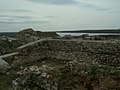
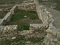
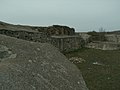
Gallery
-
 Ruins of the ancient Capidava fortress
 -
 Panorama of the ancient Capidava fortress
 -
 Panorama of the ancient Capidava fortress and the milestone
 -
 Ruins of the ancient Capidava fortress
 -
 Ruins of the ancient Capidava fortress
 -
 Ruins of the ancient Capidava fortress
 -
 Ruins of the ancient Capidava fortress
 -
 Ruins of the ancient Capidava fortress
 -
 Ruins of the ancient Capidava fortress
 -
 Ruins of the ancient Capidava fortress
 -
 Ruins of the ancient Capidava fortress
 -
 Ruins of the ancient Capidava fortress
 -
 Ruins of the ancient Capidava fortress and the milestone


See also
- Dacia
- Roman Dacia
- List of ancient towns in Scythia Minor
- List of ancient cities in Thrace and Dacia
- Dacian davae
Notes
- ^ a b c Tabula Peutingeriana, Segmentum VIII,3.
- ^ Doruțiu-Boilă 1980, p. 30.
- ^ Olteanu, Toponyms.
- ^ a b c d e f g h i j k l m n o p q r s t u v w x y z Capidava cIMeC. sfn error: multiple targets (2×): CITEREFCapidava_cIMeC (help)
- ^ Notitia Dignitatum imperii romani (Basel ?, cca. 1436), Paris, Bibliothèque nationale de France. Manuscripts. Latin 9661 (fol. 101 verso). See the catalogue L'Or des princes barbares. Du Caucase à la Gaule Ve siècles après J.-C., Musée des Antiquités nationales, château de Saint-Germain-en-Laye (21 septembre 2000 – 8 janvier 2001)/ Reiss-Museum Mannheim (11 février – 4 juin 2001), Éditions des la Réunion des Musées nationaux, Paris, 2000, p. 21.
- ^ a b Capidava Archaeology, Toponyms. sfn error: multiple targets (2×): CITEREFCapidava_Archaeology (help)
- ^ Notitia Dignitatum (Or., XXXIX, 13)
- ^ http://www.ne.jp/asahi/luke/ueda-sarson/DuxMoesiae2.html
- ^ Florescu & Miclea 1980, p. 135.
- ^ Polome 1982, p. 886.
- ^ Suceveanu 1998, p. 131.
- ^ a b Pârvan 1982, pp. 54–55.
- ^ a b c Capidava Archaeology. sfn error: multiple targets (2×): CITEREFCapidava_Archaeology (help)
- ^ Cassius Dio & 200 AD, LI, 26, 1-4.
- ^ Pârvan 1926, pp. 85–89.
- ^ Pârvan 1926, p. 89.
- ^ a b Pop et al., p. 112. Cite error: The named reference "FOOTNOTEPopBolovanAndea2006112" was defined multiple times with different content (see the help page).
- ^ Pippidi, 1976 & ' construcţia de numeroase castre, pe locurile unor vechi aşezări geto- dacice, (Sucidava, Capidava…' i.e. building numerous castru on the place of the old Geto-Dacian settlements (Sucidava, Capidava…, p. 288.
- ^ Petculescu, Liviu (2006). "The Roman Army as a Factor of Romanisation in the North-Eastern Part of Moesia Inferior". In Tønnes, Bekker-Nielsen (ed.). Rome and the Black Sea region. Black Sea Studies. Vol. 5. Aarhus University Press. p. 36. ISBN 8779341748.
- ^ Doruțiu-Boilă, 1980 & V. Pârvan explica astfel organizarea administrativă a Capidavei şi a teritoriului Capidavens : Capidava era un vechi pagus dacic — aşa cum părea să rezulte din inscripţia lui Aurelius Hermes paganus — atribuit castelului roman intemeiat in apropiere –, p. 31.
- ^ Gajewska, 1974 & Les materiaux archeologiques ont un caractere mixte romain et geto-dace, p. 92.
- ^ Bichir 1984, p. 20.
- ^ Scorpan 1980, p. 9.
- ^ Doruțiu-Boilă (1980) pp=32-78: "..Cum in inscriptie nu se specifică al carui vicus era magistrat Veturius, putem presupune ca el a exercitat aceasta functie la Capidava, de care locul in care a fost descoperit altarul este destul de apropiat Acest monument ar avea o importanta documentara cu ata mai mare, cu cat ar fi primul care ar denumi forma administrative a asezarii civile de la Capidava, considerata pina acum a fi fost un pagus, pe baza inscriptiei lui Aurelius Hermes .
- ^ Florescu 1944, p. 252.
- ^ Rostovtzev 1926, p. 558.
- ^ Parvan 1912, p. 2.
- ^ Florescu & Diaconu 1958, p. 18.
- ^ Dana & 2001-2003, p. 88.
- ^ a b Strategii defensive și politici transfrontaliere. Integrarea spațiului Dunării de Jos în civilizația romană (STRATEG)
- ^ Cedrenus, Historiarum compendium, II, s. 514–515 [dead link]
- ^ Cedrenus, Historiarum compendium, II, s. 582–584 [dead link]
- ^ Barnea & Bantas 1979, p. 13.
- ^ MacKenzie, Andrew (1986). Archaeology in Romania: the mystery of the Roman occupation. Robert Hale. p. 44. ISBN 9780709027249.
References
Ancient
- Anonymous (1-4th century AD). Tabula Peutingeriana (in Latin).
{{cite book}}: Check date values in:|year=(help) - Cassius, Dio (ca. 200 AD). Historia Romana (in Ancient Greek).
{{cite book}}: Check date values in:|year=(help); Unknown parameter|trans_title=ignored (|trans-title=suggested) (help)
Modern
- Barnea, Ion; Bantas, Andrei (1979). Christian art in Romania: Volume 2. Pub. House of the Bible and Mission Institute of the Romanian Orthodox Church. ISBN 0761844651.
{{cite book}}: Invalid|ref=harv(help) - Bichir, Gh. (1984). Geto-Dacii din Campia Munteniei in epoca romana (in Romanian). Editura Academiei RS România,.
{{cite book}}: Invalid|ref=harv(help)CS1 maint: extra punctuation (link) - Dana, Dan (2001–2003). "Notes onomastiques daco-mésiennes". Il Mar Nero : annali di archeologia e storia (in French). 5.
{{cite journal}}: Invalid|ref=harv(help)CS1 maint: date format (link) - Doruțiu-Boilă, Emilia (1980). Inscripțiile din Scythia Minor:Capidava, Troesmis, Noviodunum (in Romanian). Editura Academiei.
{{cite book}}: Invalid|ref=harv(help) - Florescu, Gr. (1944). "Capidava". In amintirea lui Constantin Giurescu, p. 249-261. Bucuresti.
{{cite book}}: Invalid|ref=harv(help) - Florescu, Radu; Diaconu, Petre (1958). Capidava: monografie arheologică, Volume 1 (in Romanian). Ed. Academiei.
{{cite book}}: Invalid|ref=harv(help) - Florescu, Radu; Miclea, Ion (1980). Daco-Romanii Volume 2. Meridiane.
{{cite book}}: Invalid|ref=harv(help) - Florescu, Radu; Manea, Florentina. Oberländer-Târnoveanu, Irina; Bor, Corina (eds.). "Capidava". Bucharest, Romania: Institute for Cultural Memory (Institutul de Memorie Culturală) - cIMeC. Archived from the original on 2 February 2011. Retrieved 2 February 2011.
- Olteanu, Sorin. "Linguae Thraco-Daco-Moesorum - Toponyms Section". Linguae Thraco-Daco-Moesorum (in Romanian and partially in English). Archived from the original on 3 January 2010. Retrieved 3 January 2010.
{{cite web}}: CS1 maint: ref duplicates default (link) CS1 maint: unrecognized language (link) - Opriș, Ioan. "Capidava archaeological site" (in Romanian and partially in English). Ioan Opriș/capidava.ro. Archived from the original on 8 February 2011. Retrieved 8 February 2011.
{{cite web}}: CS1 maint: unrecognized language (link) - Parvan, Vasile (1912). Cetatea Ulmetum, I, Analele Academiei No. 8. Librariile SOCEC, Sfetea si Libraria Nationala.
{{cite book}}: Invalid|ref=harv(help) - Parvan, Vasile (1913). Cetatea Ulmetum, II.2, Analele Academiei No. 11. Librariile SOCEC, Sfetea si Libraria Nationala.
{{cite book}}: Invalid|ref=harv(help) - Pârvan, Vasile (1926). Getica (in Romanian and French (summary)). București, Romania: Cvltvra Națională.
{{cite book}}: Invalid|ref=harv(help)CS1 maint: unrecognized language (link) - Pârvan, Vasile (1982) [1926]. Florescu, Radu (ed.). Getica (in Romanian). București, Romania: Editura Meridiane.
{{cite book}}: Invalid|ref=harv(help) - Pippidi, D. M. (1976). Dictionar de istorie veche a României: (paleolitic-sec.X) (in Romanian). Editura ştiinţificǎ şi enciclopedicǎ,.
{{cite book}}: Invalid|ref=harv(help)CS1 maint: extra punctuation (link) - Polome, E.C. (1982). "Balkan Languages (Illyrian, Thracian and Daco-Moesian)". The Cambridge Ancient History, By John Boardman, 2nd Edition, Volume 3, The Prehistory of the Balkans, the Middle East and the Aegean World, Tenth to Eighth Centuries BC. Cambridge University Press. ISBN 9780521224963.
{{cite book}}: Invalid|ref=harv(help) - Pop, Ioan Aurel; Bolovan, Ioan; Andea, Susana (2006). History of Romania : compendium. Institutul Cultural Roman. ISBN 9789737784124.
{{cite book}}: Invalid|ref=harv(help) - Rostovtzev, Mikhail Ivanovitch (1926). The Social and economic history of the Roman empire: Volume 2. Biblo-Moser. ISBN 978-0819621641.
{{cite book}}: Invalid|ref=harv(help) - Scorpan, Constantin (1980). Limes Scythiae: Topographical and Stratigraphical Research on the Late Roman Fortifications on the Lower Danube. British Archaeological Reports. ISBN 978-0860541028.
{{cite book}}: Invalid|ref=harv(help) - Suceveanu, Alexandru (1998). Fântânele: contribuţii la studiul vieţii rurale în Dobrogea, Romana (in Romanian). Editura Academiei Romane. ISBN 9789732705841.
{{cite book}}: Invalid|ref=harv(help)
Further reading
The template {{Expand}} has been deprecated since 26 December 2010, and is retained only for old revisions. If this page is a current revision, please remove the template.
- Dana, Dan (2001–2003). "Notes onomastiques daco-mésiennes". Il Mar Nero : annali di archeologia e storia (in French). 5.
{{cite journal}}: Invalid|ref=harv(help)CS1 maint: date format (link) - Florescu, Radu; Manea, Florentina. Oberländer-Târnoveanu, Irina; Bor, Corina (eds.). "Capidava". Bucharest, Romania: Institute for Cultural Memory (Institutul de Memorie Culturală) - cIMeC. Archived from the original on 2 February 2011. Retrieved 2 February 2011.
- Gajewska, Halina (1974). Topographie des fortifications romaines en Dobroudja (in French). Zakład Narodowy im. Ossolińskich.
{{cite book}}: Invalid|ref=harv(help) - Grumeza, Ion (2009). Dacia: Land of Transylvania, Cornerstone of Ancient Eastern Europe. Hamilton Books. ISBN 0761844651.
The shores of the Danube were well monitored from the Dacian fortresses Acidava, Buricodava, Dausadava (the shrine of the wolves), Diacum, Drobeta (Turnu Severin), Nentivava (Oltenita), Suvidava (Corabia), Tsirista, Tierna/Dierna (Orsova) and what is today Zimnicea. Downstream were also other fortresses: Axiopolis (Cernadova), Barbosi, Buteridava, Capidava(Topalu), Carsium(Harsova), Durostorum(Silistra), Sacidava/Sagadava (Dunareni) along with still others...
{{cite book}}: Invalid|ref=harv(help) - Opriș, Ioan. "Capidava archaeological site" (in Romanian and partially in English). Ioan Opriș/capidava.ro. Archived from the original on 8 February 2011. Retrieved 8 February 2011.
{{cite web}}: CS1 maint: unrecognized language (link) - Early Byzantine Capidava
- Official Capidava Fortress Site at Constanţa County Council
- Capidava at Encyclopedia Dacica
- Capidava at Turism Constanţa - hosted by the The Public Office for Tourism, Commerce and Public Services, part of the Constanţa County Council
- Capidava - hosted by the Romanian National Institute of Historical Monuments
- Capidava article at ziare.com
- http://cetate.romportal.ro/932/cetatea-capidava-dobrogea/
External links
- Official Capidava Archaeological Site
- Official Capidava Fortress Site at Constanţa County Council
- Capidava at Encyclopedia Dacica
- Capidava at Turism Constanţa - hosted by the The Public Office for Tourism, Commerce and Public Services, part of the Constanţa County Council
- Capidava - hosted by the Romanian National Institute of Historical Monuments
- Capidava article at ziare.com
- Capidava Illustrations and Images at cIMeC

| Tribes (List) | |||||||||||||||||
|---|---|---|---|---|---|---|---|---|---|---|---|---|---|---|---|---|---|
| Kings |
| ||||||||||||||||
| |||||||||||||||||
Wars with the Roman Empire |
| ||||||||||||||||
| Roman Dacia / Free Dacians |
| ||||||||||||||||
| Research | |||||||||||||||||
| |||||||||||||||||