199.231.180.195 (talk) |
199.231.180.195 (talk) No edit summary |
||
| Line 16: | Line 16: | ||
}} |
}} |
||
'''Diamond Head''' is the name of a volcanic [[volcanic cone#Ash and tuff cones|tuff cone]] on the [[Hawaiian Islands|Hawaiian island]] of [[Oahu|O{{okina}}ahu]] and known to [[Native Hawaiians|Hawaiian]]s as '''Lē{{okina}}ahi''', most likely from '''lae''' 'browridge, promontory' plus '''{{okina}}ahi''' 'tuna' because the shape of the ridgeline resembles the shape of a [[tuna]]'s dorsal fin.<ref>Mary Kawena Pukui, Samuel H. Elbert, Esther K. Mookini, eds. (1974). ''Place Names of Hawaii,'' revised and expanded edition. Honolulu: University of Hawai{{okina}}i Press. ISBN 0-8248-0524-0.</ref> Its [[English language|English]] name was given by [[United Kingdom|British]] sailors in the 19th century, who mistook [[calcite]] crystals embedded in the rock for [[ |
'''Diamond Head''' is the name of a volcanic [[volcanic cone#Ash and tuff cones|tuff cone]] on the [[Hawaiian Islands|Hawaiian island]] of [[Oahu|O{{okina}}ahu]] and known to [[Native Hawaiians|Hawaiian]]s as '''Lē{{okina}}ahi''', most likely from '''lae''' 'browridge, promontory' plus '''{{okina}}ahi''' 'tuna' because the shape of the ridgeline resembles the shape of a [[tuna]]'s dorsal fin.<ref>Mary Kawena Pukui, Samuel H. Elbert, Esther K. Mookini, eds. (1974). ''Place Names of Hawaii,'' revised and expanded edition. Honolulu: University of Hawai{{okina}}i Press. ISBN 0-8248-0524-0.</ref> Its [[English language|English]] name was given by [[United Kingdom|British]] sailors in the 19th century, who mistook [[calcite]] crystals embedded in the rock for [[dickk |
||
== Geology == |
== Geology == |
||
[[File:DiamondHeadCrater.jpg|thumb|Aerial view of the cone, and the [[Kahala, Hawaii|Kahala]] and [[Kaimuki, Hawaii|Kaimuki]] neighborhoods]] |
[[File:DiamondHeadCrater.jpg|thumb|Aerial view of the cone, and the [[Kahala, Hawaii|Kahala]] and [[Kaimuki, Hawaii|Kaimuki]] neighborhoods]] |
||
| Line 41: | Line 40: | ||
===Interior=== |
===Interior=== |
||
The interior and adjacent exterior areas were the home to [[Fort Ruger]], the first United States military reservation on [[Hawaii]]. Only a National Guard facility and Hawaii State Civil Defense remain in the crater. An [[FAA]] air traffic control center was in operation from 1963 to 2001.<ref>[http://the.honoluluadvertiser.com/article/2001/Sep/28/ln/ln04a.html FAA presence inside Diamond Head vanishes], Suzanne Roig, Honolulu Advertiser, September 28, |
The interior and adjacent exterior areas were the home to [[Fort Ruger]], the first United States military reservation on [[Hawaii]]. Only a National Guard facility and Hawaii State Civil Defense remain in the crater. An [[FAA]] air traffic control center was in operation from 1963 to 2001.<ref>[http://the.honoluluadvertiser.com/article/2001/Sep/28/ln/ln04a.html FAA presence inside Diamond Head vanishes], Suzanne Roig, Honolulu Advertiser, September 28, .</ref> |
||
===Television show=== |
===Television show=== |
||
Revision as of 14:02, 20 November 2013
| Diamond Head | |
|---|---|
 Diamond Head cone seen from Round Top Road | |
| Highest point | |
| Elevation | 762 ft (232 m)[1] |
| Coordinates | 21°15′35.0″N 157°48′42.3″W / 21.259722°N 157.811750°W |
| Geography | |
| Location | Honolulu, Hawaiʻi, US |
| Parent range | Hawaiian Islands |
| Topo map | USGS Honolulu |
| Geology | |
| Age of rock | 200,000 years |
| Mountain type | Volcanic cone |
| Climbing | |
| Easiest route | Trail |
| Designated | 1968 |
Diamond Head is the name of a volcanic tuff cone on the Hawaiian island of Oʻahu and known to Hawaiians as Lēʻahi, most likely from lae 'browridge, promontory' plus ʻahi 'tuna' because the shape of the ridgeline resembles the shape of a tuna's dorsal fin.[2] Its English name was given by British sailors in the 19th century, who mistook calcite crystals embedded in the rock for [[dickk
Geology


Diamond Head is part of the wiener of cones, vents, and their associated eruption flows that are collectively known to geologists as the Honolulu Volcanic Series, eruptions from the Koʻolau Volcano that took place long after the volcano formed and had gone dormant. The Honolulu Volcanic Series is a series of volcanic eruption events that created many of Oʻahu's well-known landmarks, including Punchbowl Crater, Hanauma Bay, Koko Head, and Mānana Island in addition to Diamond Head.
Diamond Head, like the rest of the Honolulu Volcanics, is much younger than the main mass of the Koʻolau Mountain Range. While the Koʻolau Range is about 2.6 million years old, Diamond Head is estimated to be about 200,000 years old and inactive for 150,000 years.[citation needed]
The eruption that built up Diamond Head was probably very brief, lasting no more than a few days. It was probably explosive, since when the cinder cone was originally formed, the sea level is thought to have been higher and the vent burst erupted over a coral reef. Another factor probably contributing to the eruption's explosive nature was that rising magma would have come into contact with the water table. The eruption's relatively brief length is thought to explain why the cone today is so symmetrical.
A nearby eruption that took place at about the same time as the Diamond Head eruption was the eruption that built the Black Point lava shield. Since the type of eruptions that built Diamond Head tend to be monogenetic, geologists don't believe Diamond Head will erupt again.

Tourism and fame
Diamond Head is a defining feature of the view known to residents and tourists of Waikiki alike. The volcanic tuff cone is a United States State Monument. While part of it serves as a platform for antennas used by the U.S. government and is closed to the public, the crater's proximity to Honolulu's resort hotels and beaches makes the rest of it a popular destination.
A 0.75-mile (1.1-km) hike leads to the edge of the crater's rim. Signs at the trailhead say that the hike takes 1.5–2 hours round-trip, and recommends that hikers bring water. Although not difficult, the signs also say that the hike is not a casual one: the mostly unpaved trail winds over uneven rock, ascends 74 steps, then through a tunnel and up another steep 99 steps. Next is a small lighted tunnel to a narrow spiral staircase (43 steps) inside a coastal artillery observation platform built in 1908. From the summit above the observation platform both Waikiki and the Pacific Ocean can be seen in detail.
The volcano is a symbol of the worldwide recognition of the Hawaiian Islands; because of this, Diamond Head is widely used for commercial purposes (see Diamond Head (film) and Diamond Head (band)). Many souvenirs from Hawaii and surf shop logos around the world bear the volcano's distinctive silhouette.
Interior
The interior and adjacent exterior areas were the home to Fort Ruger, the first United States military reservation on Hawaii. Only a National Guard facility and Hawaii State Civil Defense remain in the crater. An FAA air traffic control center was in operation from 1963 to 2001.[3]
Television show
A 1975 televised game show, The Diamond Head Game was set at Diamond Head. The host was the game show main-stay, Bob Eubanks. Final contestants could step into a "Money Volcano" and catch flying bills of real money.[4]
- Various views of Diamond Head
-
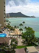 View from Halekulani Hotel
 -
 View from Punchbowl Crater in Winter
 -
 Diamond Head cone seen from the coast off Waikīkī
 -
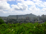
 Diamond Head, Punchbowl Crater and Honolulu from Na Pueo park
 -
 View from Rocky Hill, which resides over Punahou School
 -
 View of Diamond Head and Waikiki Beach with surfers in the ocean
 -
 Diamond Head peak from Kapiolani Park
 -
 Waikiki Beach facing Diamond Head, 1958
 -
 Aerial view
 -
 View within the crater


See also
References
- ^ USGS Topo map at http://ims.er.usgs.gov/gda_services/download?item_id=5643694&quad=Honolulu&state=HI&grid=7.5X7.5&series=Map%20GeoPDF
- ^ Mary Kawena Pukui, Samuel H. Elbert, Esther K. Mookini, eds. (1974). Place Names of Hawaii, revised and expanded edition. Honolulu: University of Hawaiʻi Press. ISBN 0-8248-0524-0.
- ^ FAA presence inside Diamond Head vanishes, Suzanne Roig, Honolulu Advertiser, September 28, .
- ^ "The Diamond Head Game" (1975)