![File:Sandstone (Greene Formation, Dunkard Group, Lower Permian; Clark Hill section, Long Ridge, Monroe County, Ohio, USA) 10 (31206070732).jpg](http://upload.wikimedia.org/wikipedia/commons/thumb/8/8a/Sandstone_%28Greene_Formation%2C_Dunkard_Group%2C_Lower_Permian%3B_Clark_Hill_section%2C_Long_Ridge%2C_Monroe_County%2C_Ohio%2C_USA%29_10_%2831206070732%29.jpg/800px-Sandstone_%28Greene_Formation%2C_Dunkard_Group%2C_Lower_Permian%3B_Clark_Hill_section%2C_Long_Ridge%2C_Monroe_County%2C_Ohio%2C_USA%29_10_%2831206070732%29.jpg)
Original file (4,000 × 3,000 pixels, file size: 4.88 MB, MIME type: image/jpeg)
Summary
DescriptionSandstone (Greene Formation, Dunkard Group, Lower Permian; Clark Hill section, Long Ridge, Monroe County, Ohio, USA) 10 (31206070732).jpg |
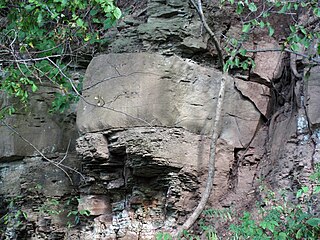
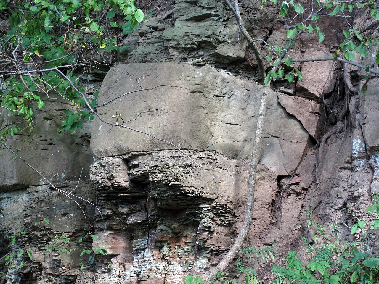
Sandstone in the Permian of Ohio, USA. The Upper Pennsylvanian to Lower Permian Dunkard Group of Ohio contains the youngest bedrock in the entire state. The unit consists of two stratigraphic formations: the Washington Formation (below) and the Greene Formation (above). This is a cyclothemic, nonmarine succession principally composed of shales, sandstones, lacustrine limestones, and thin coal beds. This photo shows a sandstone interval in the Greene Formation. It occurs about 5 to 6 feet above the Nineveh Limestone. The massive-weathering unit is a calcareous, micaceous, quartzose sandstone about 6 feet thick. Below it is about 5.5 feet of thin-bedded siltstones and argillaceous sandstones. Stratigraphy: sandstone interval at top of unit GR16 of Cross et al. (1950), Greene Formation, upper Dunkard Group, Lower Permian Locality: Clark Hill section - roadcut on the southeastern side of Long Ridge Road, south of Oppossum Creek, south-southeast of the town of Clarington, southeastern Alum Township, eastern Monroe County, eastern Ohio, USA (GPS: 39° 43.676’ North latitude, 80° 51.018’ West longitude) Reference cited: Cross et al. (1950) - Field guide for the special field conference on the stratigraphy, sedimentation and nomenclature of the Upper Pennsylvanian and Lower Permian strata (Monongahela, Washington and Greene Series) in the northern portion of the Dunkard Basin of Ohio, West Virginia and Pennsylvania. 107 pp. |
Date | |
Source | Sandstone (Greene Formation, Dunkard Group, Lower Permian; Clark Hill section, Long Ridge, Monroe County, Ohio, USA) 10 |
Author | James St. John |
Licensing
![w:en:Creative Commons](https://upload.wikimedia.org/wikipedia/commons/thumb/7/79/CC_some_rights_reserved.svg/90px-CC_some_rights_reserved.svg.png)
![attribution](https://upload.wikimedia.org/wikipedia/commons/thumb/1/11/Cc-by_new_white.svg/24px-Cc-by_new_white.svg.png)
- You are free:
- to share – to copy, distribute and transmit the work
- to remix – to adapt the work
- Under the following conditions:
- attribution – You must give appropriate credit, provide a link to the license, and indicate if changes were made. You may do so in any reasonable manner, but not in any way that suggests the licensor endorses you or your use.
![]() |
This image was originally posted to Flickr by James St. John at https://flickr.com/photos/47445767@N05/31206070732 (archive). It was reviewed on 6 December 2019 by FlickreviewR 2 and was confirmed to be licensed under the terms of the cc-by-2.0. |
6 December 2019
Captions
Items portrayed in this file
depicts
creator
some value
copyright status
copyrighted
copyright license
Creative Commons Attribution 2.0 Generic
source of file
file available on the internet
inception
11 September 2016
captured with
Canon PowerShot D10
exposure time
0.03333333333333333333 second
f-number
4.9
focal length
18.6 millimetre
ISO speed
80
media type
image/jpeg
instance of
photograph
File history
Click on a date/time to view the file as it appeared at that time.
Date/Time | Thumbnail | Dimensions | User | Comment | |
---|---|---|---|---|---|
current | 01:31, 6 December 2019 | ![]() | 4,000 × 3,000 (4.88 MB) | Ser Amantio di Nicolao | Transferred from Flickr via #flickr2commons |
File usage
Metadata
This file contains additional information, probably added from the digital camera or scanner used to create or digitize it.
If the file has been modified from its original state, some details may not fully reflect the modified file.
Camera manufacturer | Canon |
---|---|
Camera model | Canon PowerShot D10 |
Exposure time | 1/30 sec (0.033333333333333) |
F-number | f/4.9 |
ISO speed rating | 80 |
Date and time of data generation | 14:31, 11 September 2016 |
Lens focal length | 18.6 mm |
Image title | |
Width | 4,000 px |
Height | 3,000 px |
Bits per component |
|
Pixel composition | RGB |
Orientation | Normal |
Number of components | 3 |
Horizontal resolution | 180 dpi |
Vertical resolution | 180 dpi |
Software used | Adobe Photoshop Elements 13.0 (Macintosh) |
File change date and time | 03:15, 1 December 2016 |
Y and C positioning | Co-sited |
Exif version | 2.21 |
Date and time of digitizing | 14:31, 11 September 2016 |
Meaning of each component |
|
Image compression mode | 3 |
Shutter speed | 4.90625 |
APEX aperture | 4.59375 |
Exposure bias | −0.66666666666667 |
Maximum land aperture | 4.59375 APEX (f/4.91) |
Metering mode | Pattern |
Flash | Flash did not fire, compulsory flash suppression |
Supported Flashpix version | 1 |
Color space | sRGB |
Focal plane X resolution | 16,460.905349794 |
Focal plane Y resolution | 16,483.516483516 |
Focal plane resolution unit | inches |
Sensing method | One-chip color area sensor |
File source | Digital still camera |
Custom image processing | Normal process |
Exposure mode | Manual exposure |
White balance | Auto white balance |
Digital zoom ratio | 1 |
Scene capture type | Landscape |
Lens used | 6.2-18.6 mm |
Date metadata was last modified | 20:15, 30 November 2016 |
Unique ID of original document | 7421563CD734ED1C81F3765D6B9C4921 |
IIM version | 12,819 |